


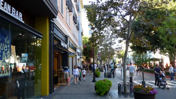
Despite its mostly sprawling conditions, San Jose has recently prioritized walkable, dense urban environments. But should the city focus its development downtown or build a connected network of urban neighborhoods?
Urbanists are keeping a close eye on the development prospects of San Jose in the Silicon Valley. The sprawling city has, in recent years, attempted to overcome its suburban development patterns, “[shifting] its strategic focus to increasingly dense, urban development, implementing a downtown high-rise incentive program, fast-tracking new residential towers and adding citywide bike lanes,” writes Lauren Hepler.
New development possibilities outside of Downtown, however, stir controversy among Downtown stakeholders who would like to concentrate development in the core. The controversy was given new fuel at the hint of large-scale development plans in a section of town called Santana Row. In an earlier article, Hepler details the deal creating the consternation: “The owner of the San Jose shopping and socializing hub, Maryland-based Federal Realty Investment Trust, Wednesday said it has entered ‘a long-term’ land lease for the 11.6-acre Century Theatres site located just across Winchester Boulevard from Santana Row.”
The possibilities seem in line with the urban ambitions of the city, “[but] any new development would likely run into old criticisms; Santana Row's location outside of downtown San Jose has always been a sticking point for advocates of more centralized urban development,” explains Halpern in the later article.
Others, however, argue that San Jose can have more than one focal point of development. Even the august observer SPUR argued for the city “to better link and promote areas surrounding downtown, like the Alameda, Japantown, Santana Row and Willow Glen,” in a recent report on San Jose. Hepler quotes the report, which says the city should "reframe the surrounding areas as an asset to downtown, not a threat."
FULL STORY: The Santana Row conundrum: Is San Jose's future urban density, suburban sprawl or both?

Can Urbanist Islands Make a Difference Where Sprawl Reigns?
The product of a single developer, San Jose's Santana Row is a pocket of urbanism in a sea of sprawl. But can it influence development patterns beyond its bounds, and should it?

Pedestrian-Friendly Malls Continue to Gain Popularity
Providence, Rhode Island is one of many cities to get mall-like retail center built with walkability in mind and set around a Plaza.
SPUR: The Bay Area Has A Sprawl Problem
SPUR states its case clearly by announcing, “We believe cities are the key to our future” at the opening of a new report called “SPUR’s Agenda for Change.”

National Parks Layoffs Will Cause Communities to Lose Billions
Thousands of essential park workers were laid off this week, just before the busy spring break season.

Retro-silient?: America’s First “Eco-burb,” The Woodlands Turns 50
A master-planned community north of Houston offers lessons on green infrastructure and resilient design, but falls short of its founder’s lofty affordability and walkability goals.

Delivering for America Plan Will Downgrade Mail Service in at Least 49.5 Percent of Zip Codes
Republican and Democrat lawmakers criticize the plan for its disproportionate negative impact on rural communities.

Test News Post 1
This is a summary

Test News Headline 46
Test for the image on the front page.

Balancing Bombs and Butterflies: How the National Guard Protects a Rare Species
The National Guard at Fort Indiantown Gap uses GIS technology and land management strategies to balance military training with conservation efforts, ensuring the survival of the rare eastern regal fritillary butterfly.
Urban Design for Planners 1: Software Tools
This six-course series explores essential urban design concepts using open source software and equips planners with the tools they need to participate fully in the urban design process.
Planning for Universal Design
Learn the tools for implementing Universal Design in planning regulations.
EMC Planning Group, Inc.
Planetizen
Planetizen
Mpact (formerly Rail~Volution)
Great Falls Development Authority, Inc.
HUDs Office of Policy Development and Research
NYU Wagner Graduate School of Public Service