


Seth Kadish says he was born with an innate sense of direction. As such, he appreciates street grids oriented to cardinal directions. The phenomena interested him enough to create a graphic that visualizes the orientation of 12 urban areas.
“If you’re like me, and you use the Sun to navigate, you probably appreciate cities with gridded street plans that are oriented in the cardinal directions,” writes Seth Kadish in introducing a cool visualization exercise that produced a graphic representation of the orientation of street grids for 12 metropolitan areas around the United States.
Like many of us, Kadish has noticed how the orientation of each city is as unique as the city itself: “…not all urban planners settled on such a simple layout for road networks. For some developers, topography or water may have gotten in the way. Others may not have appreciated the efficiency of the grid.” To examine the differences in orientation, Kadish created a visualization that compares the relative degree to which city streets are gridded.
Here are a few of Kadish’s observations from the visualization; “The plots reveal some stark trends. Most of the counties considered do conform to a grid pattern. This is particularly pronounced with Chicago, even though much of Cook County is suburban. Denver, Jacksonville, Houston, and Washington, D.C., also have dominant grid patterns that are oriented in the cardinal directions. While Philadelphia and New York are primarily gridded, their orientations are slightly skewed from the traditional N-E-S-W bearings.”
FULL STORY: On and Off the Street Grid: Relative Distributions of Road Orientations

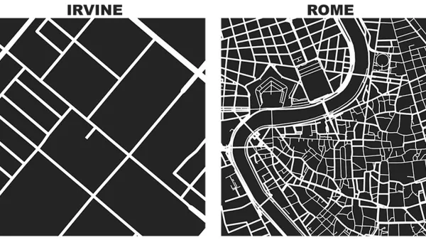
Friday Eye Candy: Comparing a Square Mile of the World's Famous Cities
Street networks and city blocks, reduced to their fundamental attributes, reveal the vast differences between cities.

The Dots of Connectivity and Broken Cultural Links
Connectivity is not just a question of geometry, according to this article by Fanis Grammenos. It's critical to consider what people connect for and how.

A 'Cul-De-Tax' for the Cul-De-Sac?
A recent study studying the contemporary planning profession's rejection of the cul-de-sac includes a proposal to create more economic disincentives for inefficient street grid patterns.

National Parks Layoffs Will Cause Communities to Lose Billions
Thousands of essential park workers were laid off this week, just before the busy spring break season.

Retro-silient?: America’s First “Eco-burb,” The Woodlands Turns 50
A master-planned community north of Houston offers lessons on green infrastructure and resilient design, but falls short of its founder’s lofty affordability and walkability goals.

Delivering for America Plan Will Downgrade Mail Service in at Least 49.5 Percent of Zip Codes
Republican and Democrat lawmakers criticize the plan for its disproportionate negative impact on rural communities.

Test News Post 1
This is a summary

Test News Headline 46
Test for the image on the front page.

Balancing Bombs and Butterflies: How the National Guard Protects a Rare Species
The National Guard at Fort Indiantown Gap uses GIS technology and land management strategies to balance military training with conservation efforts, ensuring the survival of the rare eastern regal fritillary butterfly.
Urban Design for Planners 1: Software Tools
This six-course series explores essential urban design concepts using open source software and equips planners with the tools they need to participate fully in the urban design process.
Planning for Universal Design
Learn the tools for implementing Universal Design in planning regulations.
EMC Planning Group, Inc.
Planetizen
Planetizen
Mpact (formerly Rail~Volution)
Great Falls Development Authority, Inc.
HUDs Office of Policy Development and Research
NYU Wagner Graduate School of Public Service