


"Location is the new cookie," says Simon Thompson of Esri, referencing the software in a browser that tracks the websites people visit. Meet the new apps making it happen.
With a new app called Indoor Atlas, "anyone can use a smartphone’s compass to navigate the interior," writes Quentin Hardy. The new app will bring about the probably overdue convergence of location technology and crowdsourcing in indoor settings. In fact, says Hardy, "our indoor lives will be mapped much as street addresses are today, challenging both conventional business practices and human intimacy."
"A Finnish company called IndoorAtlas has figured out that all buildings have a unique magnetic 'fingerprint' — and has solved how to use that to determine locations inside a structure to within six feet. That is enough to take a consumer to a product in a crowded supermarket, or figure out the location of, say, a half-dozen workers in a building full of them. It’s also much better than cell phone towers can do."
Here's how a savvy marketer could use the app: "IndoorAtlas has enjoyed some success selling the service to stores in Finland. In at least one case, shoppers can load their week’s shopping into their phones, and get interior directions about where every product is located, and how to efficiently walk through the store to get everything."
The article compares the technology to that of OpenStreetMap—a favorite among planners—and predicts an eventual integration of interior and exterior location technologies. "Maps of building interiors, combining the visual logs of OpenSteetMap and the magnetic fingerprints, seem like something that could be easily cobbled together. At that point, a person could get directions that extend all the way to how to walk right to a person’s cubicle."
Hardy mentions two other technologies that might help lead the revolution: Urban Engines and Euclid Analytics.
FULL STORY: Mapping Our Interiors

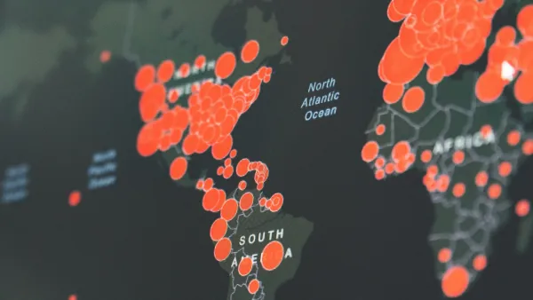
Visualizing the Coronavirus Pandemic
Mapping of the crisis is producing a fascinating and important trove of cartographic records.

An App for California State Parks
California's Department of Parks and Recreation is getting into the app business. It is hoped that CaliParks will help improve access to the state's parks for young people and minorities.
CityMap Expands to the Global Stage with its Social Mapping System
The owners of CityMap call it one of the most social and most monetizable maps in the world. With a new expansion plan announced this week, the app—which launched in 2012 with a map of every shop in New York City—is going global.

National Parks Layoffs Will Cause Communities to Lose Billions
Thousands of essential park workers were laid off this week, just before the busy spring break season.

Retro-silient?: America’s First “Eco-burb,” The Woodlands Turns 50
A master-planned community north of Houston offers lessons on green infrastructure and resilient design, but falls short of its founder’s lofty affordability and walkability goals.

Delivering for America Plan Will Downgrade Mail Service in at Least 49.5 Percent of Zip Codes
Republican and Democrat lawmakers criticize the plan for its disproportionate negative impact on rural communities.

Test News Post 1
This is a summary

Test News Headline 46
Test for the image on the front page.

Balancing Bombs and Butterflies: How the National Guard Protects a Rare Species
The National Guard at Fort Indiantown Gap uses GIS technology and land management strategies to balance military training with conservation efforts, ensuring the survival of the rare eastern regal fritillary butterfly.
Urban Design for Planners 1: Software Tools
This six-course series explores essential urban design concepts using open source software and equips planners with the tools they need to participate fully in the urban design process.
Planning for Universal Design
Learn the tools for implementing Universal Design in planning regulations.
EMC Planning Group, Inc.
Planetizen
Planetizen
Mpact (formerly Rail~Volution)
Great Falls Development Authority, Inc.
HUDs Office of Policy Development and Research
NYU Wagner Graduate School of Public Service