


A new report finds that residents of Arizona are driving less—much, much less. Arizonans drive less that they did in the 1990s, in fact. Despite these trends, the state government has not adjusted its traffic forecasting models.
Angie Schmitt shares new of a new report, "Bikes, Trains, and Less Driving [pdf]," by the Arizona Public Interest Research Group.
Here's how the report sums up its findings: "Between 2005-2012, Arizona saw a 10.5 percent decline in annual vehicle miles traveled per capita. Arizonans drive fewer total miles today than seven years ago, and fewer per person than we did in 1994."
Two of the report's takeaways, as identified by Schmitt:
- "In notoriously sprawling Phoenix, people are starting to ditch their cars. Between 2006 and 2011, the share of households with two or more vehicles decreased 2.9 percent, PIRG reports. And the total number of cars and trucks on the state’s roads is dropping, even as the population grows."
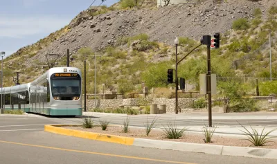
- "Meanwhile, transit ridership is on the rise in Arizona’s major cities. In Phoenix, between 2005 and 2010, total transit trips increased 16 percent. "
Schmitt also makes a point about how the trends in reduced VMT have yet to drive planning policy change at the state level.
FULL STORY: Arizonans Driving Like It’s 1994


Understanding Transit Ridership
A literature review of the factors influencing public transit ridership.
Rejecting the Popular Transit Ridership Narrative
A recent study claimed that transit ridership had reached the highest levels seen in 57 years. Wendell Cox, however, argues that the narrative about a “fundamental shift” in the transportation paradigm is a misrepresentation of the truth.
Increases in Transit Ridership Overthrowing Assumptions About Why We Ride
A recent report by the American Public Transportation Association (APTA) shows transit ridership increasing to historic levels. The surprise is that the increase occurs as gas prices have fallen.

National Parks Layoffs Will Cause Communities to Lose Billions
Thousands of essential park workers were laid off this week, just before the busy spring break season.

Retro-silient?: America’s First “Eco-burb,” The Woodlands Turns 50
A master-planned community north of Houston offers lessons on green infrastructure and resilient design, but falls short of its founder’s lofty affordability and walkability goals.

Delivering for America Plan Will Downgrade Mail Service in at Least 49.5 Percent of Zip Codes
Republican and Democrat lawmakers criticize the plan for its disproportionate negative impact on rural communities.

Test News Post 1
This is a summary

Test News Headline 46
Test for the image on the front page.

Balancing Bombs and Butterflies: How the National Guard Protects a Rare Species
The National Guard at Fort Indiantown Gap uses GIS technology and land management strategies to balance military training with conservation efforts, ensuring the survival of the rare eastern regal fritillary butterfly.
Urban Design for Planners 1: Software Tools
This six-course series explores essential urban design concepts using open source software and equips planners with the tools they need to participate fully in the urban design process.
Planning for Universal Design
Learn the tools for implementing Universal Design in planning regulations.
EMC Planning Group, Inc.
Planetizen
Planetizen
Mpact (formerly Rail~Volution)
Great Falls Development Authority, Inc.
HUDs Office of Policy Development and Research
NYU Wagner Graduate School of Public Service