


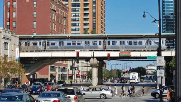
A new report challenges assumptions about Chicago's transit system, identifying well-populated neighborhoods that are cut off from frequent transit service.
John Hilkevitch shares news of a new report by the Center for Neighborhood Technology, due for release later this week. Here's how Hilkevitch summarizes the report's findings: "About 1 out of every 10 people in Cook County, roughly 438,500 residents, live in 'transit deserts' that are cut off from fast, frequent train and bus service." The study, explains Hilkevitch, "for the first time identifies dozens of Chicago-area mass transit dead zones and maps them in relation to major job clusters."
More than just residential neighborhoods lack adequate transit service, according to the report. The study also "found that four of the Chicago region's five big employment areas are in suburbs that are not well-connected to high-quality transit, making them difficult to reach without a vehicle. Those four job centers make up the northwest corridor past O'Hare International Airport, Lombard, Naperville and Oak Brook."
CTA officials, for the record, have disputed the findings of the report, saying "that more than 96 percent of the city of Chicago is not in what the study defined as a transit desert. In addition, the service levels that the study outlined to avoid the classification of a transit desert are 'standards that any transit agency in the U.S. would be unable to meet' on a 24-hour, systemwide basis, CTA spokesman Brian Steele said."
FULL STORY: 'Transit deserts' don't serve workers, study says

Chicago Transit Increasing Rail Service to Pre-Pandemic Levels
The Chicago Transit Authority is close to returning both rail and bus service to pre-pandemic schedules, with some adjustments for new travel demand.
Study: Loss of Public Transit in Chicago Would Have ‘Severe’ Mobility, Economic Consequences
The first-of-it’s kind study found that without public transit, Chicago would lose an estimated $35 billion in economic activity annually and the quality of life of residents, particularly women and low-income groups, would take a major hit.
Chicago Transit Releases 2024 Budget
The agency projects modest ridership growth while aiming to make long-term investments in bus and rail improvements.

National Parks Layoffs Will Cause Communities to Lose Billions
Thousands of essential park workers were laid off this week, just before the busy spring break season.

Retro-silient?: America’s First “Eco-burb,” The Woodlands Turns 50
A master-planned community north of Houston offers lessons on green infrastructure and resilient design, but falls short of its founder’s lofty affordability and walkability goals.

Delivering for America Plan Will Downgrade Mail Service in at Least 49.5 Percent of Zip Codes
Republican and Democrat lawmakers criticize the plan for its disproportionate negative impact on rural communities.

Test News Post 1
This is a summary

Test News Headline 46
Test for the image on the front page.

Balancing Bombs and Butterflies: How the National Guard Protects a Rare Species
The National Guard at Fort Indiantown Gap uses GIS technology and land management strategies to balance military training with conservation efforts, ensuring the survival of the rare eastern regal fritillary butterfly.
Urban Design for Planners 1: Software Tools
This six-course series explores essential urban design concepts using open source software and equips planners with the tools they need to participate fully in the urban design process.
Planning for Universal Design
Learn the tools for implementing Universal Design in planning regulations.
EMC Planning Group, Inc.
Planetizen
Planetizen
Mpact (formerly Rail~Volution)
Great Falls Development Authority, Inc.
HUDs Office of Policy Development and Research
NYU Wagner Graduate School of Public Service