


A region dominated by automobile-friendly infrastructure has released a Draft EIR for a bus rapid transit project connecting central San Jose to Palo Alto via El Camino Real.
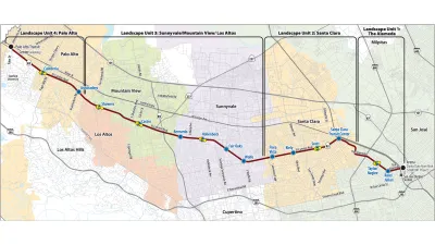
El Camino Real was the road originally used by Spanish missionaries as they founded missions throughout California. Now, that road is the focus of the latest BRT project in the Silicon Valley, destined to connect central San Jose and Palo Alto. El Camino Real runs through or nearby many downtowns on the peninsula, including San Jose, Santa Clara, Sunnyvale, Mountain View, and Palo Alto.
According to Jarrett Walker of the Human Transit blog, "[in] land use terms, the project corridor is ideal territory for transit—lots of employment and commercial destinations, with strong anchoring institutions at each end... the modern street was designed with a singular focus on auto travel time, as a six-lane divided boulevard. Auto and transit travel times continue to increase substantially as more people come to live and work in the corridor, and even more population and employment growth is forecast for the coming decades."
Santa Clara Valley Transportation Authority and the Federal Transit Administration released the Draft Environmental Impact Report, evaluating a number of alternatives varying in dedicated lane extent and various street configurations.
FULL STORY: silicon valley: bus rapid transit that's faster than driving?

Bus Rapid Transit Hitting Speed Bumps in the Silicon Valley
A proposed BRT route between Palo Alto and San Jose is the latest to hit a setback.
Tech Giants Bank on Growth, Acquire More Space
To provide room for long-term expansion, companies like Google, Facebook, and LinkedIn are buying up even more Bay Area real estate. Their flush cash reserves have them nudging out the traditional development and investment crowd.

Google Seeks New Direction for Massive Housing Proposal
The company parted ways with its development partner, signaling a shift in strategy for a proposed 15,000-unit housing and office space project on Google-owned land in Silicon Valley.

National Parks Layoffs Will Cause Communities to Lose Billions
Thousands of essential park workers were laid off this week, just before the busy spring break season.

Retro-silient?: America’s First “Eco-burb,” The Woodlands Turns 50
A master-planned community north of Houston offers lessons on green infrastructure and resilient design, but falls short of its founder’s lofty affordability and walkability goals.

Delivering for America Plan Will Downgrade Mail Service in at Least 49.5 Percent of Zip Codes
Republican and Democrat lawmakers criticize the plan for its disproportionate negative impact on rural communities.

Test News Post 1
This is a summary

Test News Headline 46
Test for the image on the front page.

Balancing Bombs and Butterflies: How the National Guard Protects a Rare Species
The National Guard at Fort Indiantown Gap uses GIS technology and land management strategies to balance military training with conservation efforts, ensuring the survival of the rare eastern regal fritillary butterfly.
Urban Design for Planners 1: Software Tools
This six-course series explores essential urban design concepts using open source software and equips planners with the tools they need to participate fully in the urban design process.
Planning for Universal Design
Learn the tools for implementing Universal Design in planning regulations.
EMC Planning Group, Inc.
Planetizen
Planetizen
Mpact (formerly Rail~Volution)
Great Falls Development Authority, Inc.
HUDs Office of Policy Development and Research
NYU Wagner Graduate School of Public Service