


One of the largest ongoing planning efforts in the city of Los Angeles is an update to the Mobility Element of the city's General Plan. A revised version of the draft "Mobility Plan 2035" was released in February.
"This week the Los Angeles Department of City Planning released a revised version of the Mobility Plan 2035 [pdf], an aspirational, wide-ranging blueprint for getting around Los Angeles in the next 20 years," reports the staff at Curbed LA. The Los Angeles Department of City Planning has been working on the update for sevral years, and the current draft incorporates changes following a round of public hearings in March 2014.
According to Curbed LA, "[the major] goals of the plan include establishing a network of 'Complete Streets' that are accessible for both people and cars, reducing greenhouse gas emissions, and solving the ever-vexing 'first-mile/last-mile' issue for getting people to and from all those transit stops already here and on the way."
The post goes on to describe the additional details of the updated version of the plan, including meter pricing, grade crossings, industrial street infrastructure, and bike racks on buses.
FULL STORY: Here's the Big Plan to Make it Way Easier to Get Around Los Angeles Over the Next 20 Years

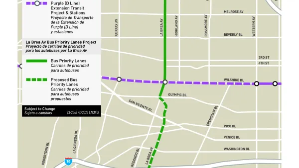
New Bus Priority Lane Under Construction in Los Angeles
La Brea Avenue will soon gain a new bus priority lane, with plans for more to come still gathering community feedback.

Report: How L.A.'s Transportation System Fails Women
According to an LADOT study, the city's women face disproportionate barriers in accessing safe, efficient transportation.

L.A. Planners Working to Shift Affordable Housing Distribution for More Equitable Results
Almost all the affordable housing development in L.A. in the past decade has occurred in majority-minority neighborhoods. The L.A. Department of City Planning is looking for ways to make sure high-income areas do more of their fair share.

National Parks Layoffs Will Cause Communities to Lose Billions
Thousands of essential park workers were laid off this week, just before the busy spring break season.

Retro-silient?: America’s First “Eco-burb,” The Woodlands Turns 50
A master-planned community north of Houston offers lessons on green infrastructure and resilient design, but falls short of its founder’s lofty affordability and walkability goals.

Delivering for America Plan Will Downgrade Mail Service in at Least 49.5 Percent of Zip Codes
Republican and Democrat lawmakers criticize the plan for its disproportionate negative impact on rural communities.

Test News Post 1
This is a summary

Test News Headline 46
Test for the image on the front page.

Balancing Bombs and Butterflies: How the National Guard Protects a Rare Species
The National Guard at Fort Indiantown Gap uses GIS technology and land management strategies to balance military training with conservation efforts, ensuring the survival of the rare eastern regal fritillary butterfly.
Urban Design for Planners 1: Software Tools
This six-course series explores essential urban design concepts using open source software and equips planners with the tools they need to participate fully in the urban design process.
Planning for Universal Design
Learn the tools for implementing Universal Design in planning regulations.
EMC Planning Group, Inc.
Planetizen
Planetizen
Mpact (formerly Rail~Volution)
Great Falls Development Authority, Inc.
HUDs Office of Policy Development and Research
NYU Wagner Graduate School of Public Service