


Until last week, the seasons never changed on satellite image software. But Mapbox's Landsat-Live program shares clear images of the Earth's surface in near-real time.
"Launched Thursday, a landmark project from Mapbox has changed the summertime paradigm for online cartography," reports Laura Bliss. "Landsat-live reveals the planet's surface in real time and in stunning resolution, fed by a constant stream of public-domain imagery from NASA’s Landsat 8 satellite."
Bliss goes on to detail the features of the new addition to the cartography toolbox, including giving credit to the U.S. Geological Survey and Amazon Web Services for making the images free and available to the public.
The result is satellite imagery that is 16 days old at the most, according to Bliss, which enables all kinds of practical applications, such as environmental and agricultural monitoring. The article also includes an embedded version and screengrabs from the Landsat-live app.
FULL STORY: Roam the World in (Almost) Real Time

Can an Upstart Mapmaker Beat Google and Microsoft at Their Own Game?
Glenn Fleishman profiles MapBox, whose 30 employees are taking on the big boys in the development of interactive street and satellite maps. The company is working with Charlie Loyd to develop "the most beautiful, clean map ever made."

Satellite, Launched Into Space Earlier This Month, to Measure Urban Heat Island Effect
A new satellite, currently residing on the International Space Station and scheduled for deployment in January, will measure and map the urban heat island effect of seven U.S. cities.
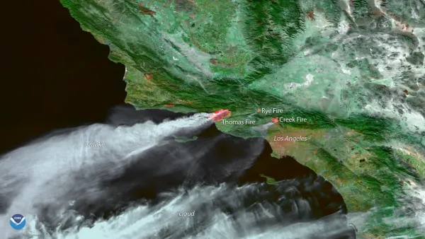
View the Smoke from the California Fires From Satellite
The National Oceanic and Atmospheric Administration has been making the most of its celestial perch to illustrate the scale of the fires currently burning in Southern California.

Analysis: Cybertruck Fatality Rate Far Exceeds That of Ford Pinto
The Tesla Cybertruck was recalled seven times last year.

National Parks Layoffs Will Cause Communities to Lose Billions
Thousands of essential park workers were laid off this week, just before the busy spring break season.

Retro-silient?: America’s First “Eco-burb,” The Woodlands Turns 50
A master-planned community north of Houston offers lessons on green infrastructure and resilient design, but falls short of its founder’s lofty affordability and walkability goals.

Test News Post 1
This is a summary

Analysis: Cybertruck Fatality Rate Far Exceeds That of Ford Pinto
The Tesla Cybertruck was recalled seven times last year.

Test News Headline 46
Test for the image on the front page.
Urban Design for Planners 1: Software Tools
This six-course series explores essential urban design concepts using open source software and equips planners with the tools they need to participate fully in the urban design process.
Planning for Universal Design
Learn the tools for implementing Universal Design in planning regulations.
EMC Planning Group, Inc.
Planetizen
Planetizen
Mpact (formerly Rail~Volution)
Great Falls Development Authority, Inc.
HUDs Office of Policy Development and Research
NYU Wagner Graduate School of Public Service