


Many smartphone users have a fitness app that they use to track their routes and progress on fitness goals. The data in these apps is a gold mine for planners, helping lead to better infrastructure investments.

Technology is changing the way we plan. Members of the public are interacting with technology in different ways, routinely using our mobile devices to communicate all kinds of information. For example, when I ask people if they have a fitness app on their phone, most say yes that they routinely track their fitness activities. How can we as planners use these fitness apps for planning purposes? Many of our cities have a goal of increasing biking, but there is limited information about preferences of people on bikes and the effectiveness of bicycle infrastructure.
Thankfully with the abundance of smartphones and fitness apps cities have a new instrument for data collection. This post highlights two fitness apps CycleTracks and Strava. My intern Patrick Holland explored how two planning organizations are using fitness apps to support transportation planning, his results are shared below.
![]() The city of Portland is using the mobile app Strava to collect data about people on bikes in addition to their traditional bike counters. The biggest advantage in using the mobile app is the ability to see complete trips. With information from the app you are able to see where people are traveling and any possible trouble points they might have. For example, Portland found that riders were consistently using the east side of an intersection and not the west, pinpointing the need for an intersection improvement, reported Margi Bradway, Active Transportation Division Manager at the Portland Bureau of Transportation.
The city of Portland is using the mobile app Strava to collect data about people on bikes in addition to their traditional bike counters. The biggest advantage in using the mobile app is the ability to see complete trips. With information from the app you are able to see where people are traveling and any possible trouble points they might have. For example, Portland found that riders were consistently using the east side of an intersection and not the west, pinpointing the need for an intersection improvement, reported Margi Bradway, Active Transportation Division Manager at the Portland Bureau of Transportation.
The city also uses the app to look for patterns of shortcuts. In one instance, the city was planning and designing a path on a two way street but noticed bicyclists were already using a church parking lot. Instead of building a path on the street; the City worked with the church to make the parking lot a safe route for cyclists.
 San Francisco County developed CycleTracks, a fitness app that uses GPS to record users bicycle trip routes, times and trip purpose. CycleTracks was developed to aid in predicting what types of routes people on bikes were likely to use, based on rider level of experience and characteristics of the thoroughfares they would ride on.
At the end of each trip, data are sent to the San Francisco County Transportation Authority for analysis. The data analysis lead to a simple conclusion: people on bikes avoid hills, a challenging thing to do in San Francisco.
- People who commute by bike are more than three times as likely to go out of their way to avoid hills.
- For every 100 feet of hill rise people are willing to bike out of their way one mile.
- Infrequent cyclists prefer bike lanes approximately twice as much as frequent cyclists
- Frequent cyclists will go out of their way by almost 10 percent to use a sharrow route.
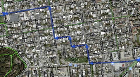
For example, cyclists go several hundred feet out of the way using "The Wiggle," a bike route through San Francisco's hills—the result feels like you have saved miles. This analysis helps planners to figure out what infrastructure works best and make informed decisions about future development.
San Francisco County has made CycleTracks available to other cities. The county collects data with CycleTracks for:
- Austin, Texas
- Monterrey, California
- Raleigh, North Carolina
- Fort Collins, Colorado
- Minneapolis/St. Paul, Minnesota
- Seattle, Washington
- Salt Lake City, Utah
- Los Angeles, California
- Toronto, Ontario
- Lexington, Kentucky
The county has also allowed CycleTracks to be rebranded and improved by other cities including:
- Lane County, Oregon
- College Station, Texas
- Charlottesville, Virginia
- Hampton Roads, Virginia
- Atlanta, Georgia
- Montreal, Quebec
- Reno, Nevada
- Philadelphia, Pennsylvania
If you're interested in using CycleTracks in your city send contact [email protected].
While many cities have incorporated apps similar to San Francisco’s CycleTracks and incorporated STRAVA it is important for your community to develop one of their own. Perhaps your community’s attitude toward infrastructure development is completely different than San Francisco's. What mobile apps has your agency been using to help support planning?

The Power of Public-Private Partnerships: Mobile Phone Apps and Municipalities
Private, crowdsourced mobile phone applications addressing urban mobility collect troves of data on how cities flow. So how can municipalities tap into these databases to accurately understand the movement of their citizens?

Best Apps for Urban Planning in 2022
Mobile apps continue to redefine the practices of planning—urban planning, regional planning, transportation planning, community planning, and rural planning included.
Top Planning Apps for 2019
Insights into the mobile app technology used in the practice and study of planning.

Analysis: Cybertruck Fatality Rate Far Exceeds That of Ford Pinto
The Tesla Cybertruck was recalled seven times last year.

National Parks Layoffs Will Cause Communities to Lose Billions
Thousands of essential park workers were laid off this week, just before the busy spring break season.

Retro-silient?: America’s First “Eco-burb,” The Woodlands Turns 50
A master-planned community north of Houston offers lessons on green infrastructure and resilient design, but falls short of its founder’s lofty affordability and walkability goals.

Test News Post 1
This is a summary

Analysis: Cybertruck Fatality Rate Far Exceeds That of Ford Pinto
The Tesla Cybertruck was recalled seven times last year.

Test News Headline 46
Test for the image on the front page.
Urban Design for Planners 1: Software Tools
This six-course series explores essential urban design concepts using open source software and equips planners with the tools they need to participate fully in the urban design process.
Planning for Universal Design
Learn the tools for implementing Universal Design in planning regulations.
EMC Planning Group, Inc.
Planetizen
Planetizen
Mpact (formerly Rail~Volution)
Great Falls Development Authority, Inc.
HUDs Office of Policy Development and Research
NYU Wagner Graduate School of Public Service