


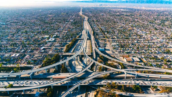
A new study explains how building new transit and density along transit corridors isn't enough alone to reduce carbon emissions in metropolitan areas.

"A Boston University study published on April 6 in the Proceedings of the National Academy of Sciences shows that a major push in cities like Denver to build dense housing, better transit systems, and more bike lanes in their urban core doesn’t necessarily lead to lower per-capita CO2 emissions," reports Bobby Magill. "That’s because suburbs continue to sprawl and residents there still drive to work."
Although Denver has been celebrated for its recent focus on its urban core, recent reports also show the metropolitan area building residential developments at a much faster pace on the fringes.
The study, according to Magill's coverage, is groundbreaking in its ability measure the impacts of growth in cities like Denver and Salt Lake City: "The study is the first to measure vehicle tailpipe emissions in major metropolitan areas by using highway traffic data over a period of time—information crucial for city planners to know their city’s impact on the climate, and to find ways to reduce their carbon footprint."
More on that point: "Conor Gately, a graduate student at Boston University’s Department of Earth and Environment and the paper’s lead author, said his team created the first nationally consistent map of vehicle CO2 emissions at a one kilometer scale over a span of 33 years between 1980 and 2012. Previous studies were limited to a single year or measured emissions at a state or national level, he said."
The article includes a lot more about the implications of the study as well as some of the debate that has already emerged over its findings.
FULL STORY: Urban Sprawl, Cars Hamper Cities’ Best Efforts on CO2


How Cities Can Lead the Way in Reducing Transportation Emissions
Decisions made at the local level can have a significant impact on emissions in the transportation sector.
How Urban Sprawl Came To Dominate U.S. Cities—And How To Change That
The auto-centric development patterns of American cities are a result of decades of misguided, but reversible, policy decisions.

The Path to Hyperdensity
The federal government has an opportunity to make a generational investment in the country's infrastructure that could fundamentally shift the way we live and move around cities.

National Parks Layoffs Will Cause Communities to Lose Billions
Thousands of essential park workers were laid off this week, just before the busy spring break season.

Retro-silient?: America’s First “Eco-burb,” The Woodlands Turns 50
A master-planned community north of Houston offers lessons on green infrastructure and resilient design, but falls short of its founder’s lofty affordability and walkability goals.

Delivering for America Plan Will Downgrade Mail Service in at Least 49.5 Percent of Zip Codes
Republican and Democrat lawmakers criticize the plan for its disproportionate negative impact on rural communities.

Test News Post 1
This is a summary

Test News Headline 46
Test for the image on the front page.

Balancing Bombs and Butterflies: How the National Guard Protects a Rare Species
The National Guard at Fort Indiantown Gap uses GIS technology and land management strategies to balance military training with conservation efforts, ensuring the survival of the rare eastern regal fritillary butterfly.
Urban Design for Planners 1: Software Tools
This six-course series explores essential urban design concepts using open source software and equips planners with the tools they need to participate fully in the urban design process.
Planning for Universal Design
Learn the tools for implementing Universal Design in planning regulations.
EMC Planning Group, Inc.
Planetizen
Planetizen
Mpact (formerly Rail~Volution)
Great Falls Development Authority, Inc.
HUDs Office of Policy Development and Research
NYU Wagner Graduate School of Public Service