


The city of Durham hosted a public workshop this week to discuss urban design plans for converting a circuitous couplet to a two-way street grid.

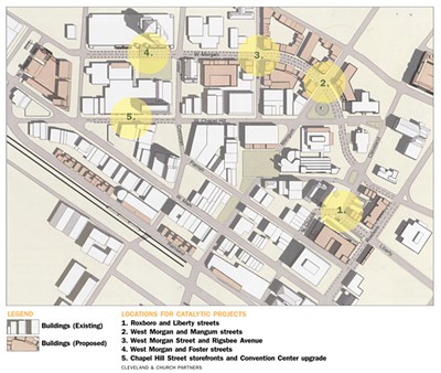
As the former tobacco manufacturing town continues to reinvent itself, the city and private developers are partnering to reconfigure infrastructure based on principles of contemporary urbanism. One idea, presented by local developer Cleveland and Church Partners, is to convert Roxboro, Mangum, Morgan, and Ramseur streets to two-way operations, with on-street parking, new connections, and pedestrian and bicycle amenities. The current street network—known as the downtown loop—consists of one-way traffic up to four lanes wide.
While moving cars quickly, it is a difficult and confusing network in a downtown that is otherwise logically laid out.
“Fifty years ago, downtowns tried to mimic the convenience of suburban shopping centers, says David Godschalk, professor emeritus at the University of North Carolina's Department of City and Regional Planning, says, "because downtowns were losing people to the malls."
New residents moving to the urban core desire walkability and streetscapes that support compact urban form, which is not supported by the current loop’s broad, bypass-style configuration. Transformative infrastructure projects like the downtown loop conversion help make downtown more attractive and convenient, which ripens the private sector market, and allows for further enhancement as new development projects come online.
This revised concept is based on public input received at the first workshop in October 2009. While the plans were created by a private entity, the city has placed them on its web site, and includes the downtown loop among a list of high-profile, infrastructure projects to consider over the long term.
FULL STORY: Ditching Durham's Downtown Loop

Durham, NC Moving ahead with High-Profile Projects
Durham City Council members may be ready to take on new debt to fund a list of big-ticket parks and transportation projects which would help keep pace with growth and enhance the community.

Study: Americans Spending Less Time Interacting in Public Space
American pedestrians are moving faster and spending less time connecting with other people when walking down city streets.

Midburbs: A New Definition of Suburbs
When the name “suburb” just doesn't quite fit.

National Parks Layoffs Will Cause Communities to Lose Billions
Thousands of essential park workers were laid off this week, just before the busy spring break season.

Retro-silient?: America’s First “Eco-burb,” The Woodlands Turns 50
A master-planned community north of Houston offers lessons on green infrastructure and resilient design, but falls short of its founder’s lofty affordability and walkability goals.

Delivering for America Plan Will Downgrade Mail Service in at Least 49.5 Percent of Zip Codes
Republican and Democrat lawmakers criticize the plan for its disproportionate negative impact on rural communities.

Test News Post 1
This is a summary

Test News Headline 46
Test for the image on the front page.

Balancing Bombs and Butterflies: How the National Guard Protects a Rare Species
The National Guard at Fort Indiantown Gap uses GIS technology and land management strategies to balance military training with conservation efforts, ensuring the survival of the rare eastern regal fritillary butterfly.
Urban Design for Planners 1: Software Tools
This six-course series explores essential urban design concepts using open source software and equips planners with the tools they need to participate fully in the urban design process.
Planning for Universal Design
Learn the tools for implementing Universal Design in planning regulations.
EMC Planning Group, Inc.
Planetizen
Planetizen
Mpact (formerly Rail~Volution)
Great Falls Development Authority, Inc.
HUDs Office of Policy Development and Research
NYU Wagner Graduate School of Public Service