


The brain has a complex, ancient relationship with place. Mental maps are the manifestation of our brains' perception of place and wayfinding. These maps can have profound impacts on how residents appreciate, and improve, their neighborhoods.
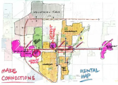
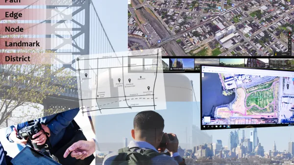
"Place" isn't just a matter of what we see before our eyes. It is also an accumulation of perceptions, histories, and even biases. That's what planner Kevin Lynch proposed in his landmark book The Image of the City, and it's a driving force in the effort to revitalize neighborhoods today.
Though Lynch wasn't a neuroscientist, it turns out that many of his theories are grounded in the physiological processes that the brain uses to orient itself and direct itself through a landscape: "after our brains locate landmarks and create paths, we begin forming edges, districts, and nodes on our mental maps, once again using memories to inform the locational information. This, in essence, are where neighborhoods begin. It's also where things get nice and weird."
"It could be a very deceiving process, because you go by what you see, not by what's really there," Sorin Adam Matei, an associate professor at Purdue who researches mental maps, told Pacific Standard. "People keep saying, location, location, location. That's not objective location, really. It's suggestive location.....A physical location that was nothing 20 years ago, by getting it to the right people and with the right name, all of a sudden becomes hot." In other words, it sometimes takes a new name to erase old memories, for better or worse.
What this means is that revitalizing blighted neighborhoods may rely as much on neuroscience as on public policy.
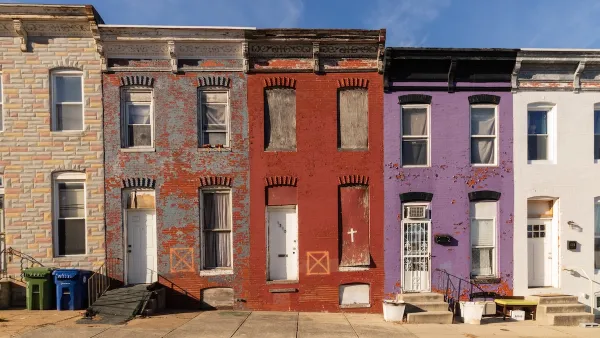
"Racist practices like redlining, used from the 1930s through the '60s to deny loans, insurance, supermarkets, and health coverage to those residing in certain neighborhoods (a practice that got its name from the literal drawing of red lines on a map to designate what areas to say blanket “nos” to), have predictably led to focused areas of blight. This has led to ensuing protests, persistent negative portrayals, a lack of funding to repair the damage, more protests, more negative portrayals, and so on."
"The first step of making improvements to any neighborhood—including the changes that are designed for original residents—comes from re-defining these quirks in our neurology. "Mental maps cannot be read apart from the stories of those who created them,” Gieseking says. "We need to be careful not only then in how we tell stories but also how we present maps."
FULL STORY: Mental Maps and the Neuroscience of Neighborhood Blight

Analyzing Lynch's City Imageability in the Digital Age
Mahbubur Meenar of Rowan University writes about a recent article he co-authored in the Journal of Planning Education and Research
Baltimore Program Could Repurpose Thousands of Vacant Housing Units
The city and state are investing $3 billion in rescuing vacant residential properties to promote homeownership and reduce blight.
The Impact of Local Entrepreneurship on Neighborhood Revitalization
Explore how local entrepreneurship boosts neighborhood revitalization, driving economic growth, creating jobs, and enhancing community bonds. Learn about the supportive role urban planners play in fostering sustainable business ecosystems.

National Parks Layoffs Will Cause Communities to Lose Billions
Thousands of essential park workers were laid off this week, just before the busy spring break season.

Retro-silient?: America’s First “Eco-burb,” The Woodlands Turns 50
A master-planned community north of Houston offers lessons on green infrastructure and resilient design, but falls short of its founder’s lofty affordability and walkability goals.

Delivering for America Plan Will Downgrade Mail Service in at Least 49.5 Percent of Zip Codes
Republican and Democrat lawmakers criticize the plan for its disproportionate negative impact on rural communities.

Test News Post 1
This is a summary

Test News Headline 46
Test for the image on the front page.

Balancing Bombs and Butterflies: How the National Guard Protects a Rare Species
The National Guard at Fort Indiantown Gap uses GIS technology and land management strategies to balance military training with conservation efforts, ensuring the survival of the rare eastern regal fritillary butterfly.
Urban Design for Planners 1: Software Tools
This six-course series explores essential urban design concepts using open source software and equips planners with the tools they need to participate fully in the urban design process.
Planning for Universal Design
Learn the tools for implementing Universal Design in planning regulations.
EMC Planning Group, Inc.
Planetizen
Planetizen
Mpact (formerly Rail~Volution)
Great Falls Development Authority, Inc.
HUDs Office of Policy Development and Research
NYU Wagner Graduate School of Public Service