


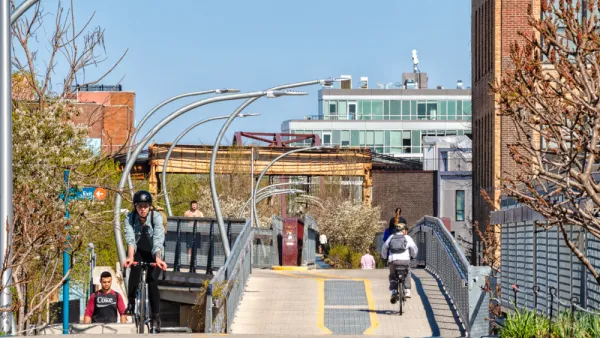
Following in the footsteps of the High Line in New York City, Chicago opened a 2.7-mile elevated park, which has already been extremely popular in its first week. Here we round up the initial reactions to The 606, as the new park is called.
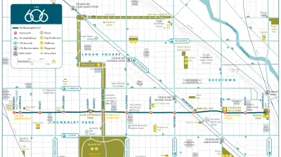
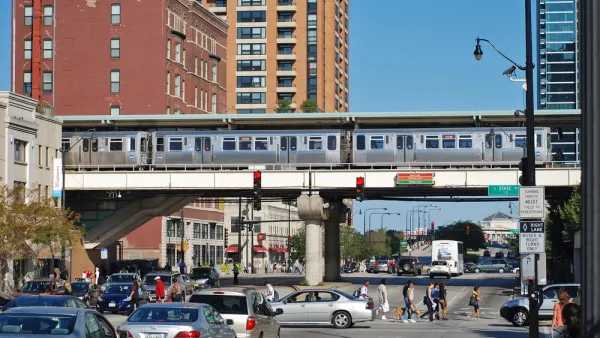
"Chicago’s long-awaited bikeway and elevated park, The 606, opened last weekend (on 6/6, no less) to a rush of pedestrians and cyclists who were eager to test out the new 2.7-mile trail after years of planning, design and construction," according to Chris Bentley.
The 606, formerly called the Bloomingdale Trail, "is as much a highway for bikes as anything else, due in part to its having been largely funded through the U.S. Department of Transportation’s Congestion Mitigation and Air Quality (CMAQ) improvement program."
Steven Vance created a time-lapse video of the entire length of The 606, which you can watch here. Vance also wrote for Streetsblog Chicago to explain how he made the video.
Bicycling west to east on the Bloomingdale Trail from Steven Vance on Vimeo.
Writing for Landscape Architecture Magazine, Zach Mortice offers more details about the funding and political support necessary for the park as well as more details about the design of the route.
FULL STORY: RIDE CHICAGO’S NEW ELEVATED PARK AND BIKE PATH, THE 606, WITH THIS TIME-LAPSE VIDEO

Bloomingdale Trail Gets New Name and Final Plan
Final plans for what will become the longest elevated park in the world where unveiled this week in Chicago. The 2.7-mile rail-to-trail conversion has been branded as The 606, a nod to the zip code digits shared by the neighborhoods along its route.
Chicago's New Strategic Plan for Transportation Prioritizes Equity and Accountability
The plan calls for safer streets, more equitable distribution of resources, and expanded community engagement.
Don't Call it The 606: Chicago's Popular Linear Park Gets a New Name
The Chicago Park District wants to be extra sure we're all clear on this.

National Parks Layoffs Will Cause Communities to Lose Billions
Thousands of essential park workers were laid off this week, just before the busy spring break season.

Retro-silient?: America’s First “Eco-burb,” The Woodlands Turns 50
A master-planned community north of Houston offers lessons on green infrastructure and resilient design, but falls short of its founder’s lofty affordability and walkability goals.

Delivering for America Plan Will Downgrade Mail Service in at Least 49.5 Percent of Zip Codes
Republican and Democrat lawmakers criticize the plan for its disproportionate negative impact on rural communities.

Test News Post 1
This is a summary

Test News Headline 46
Test for the image on the front page.

Balancing Bombs and Butterflies: How the National Guard Protects a Rare Species
The National Guard at Fort Indiantown Gap uses GIS technology and land management strategies to balance military training with conservation efforts, ensuring the survival of the rare eastern regal fritillary butterfly.
Urban Design for Planners 1: Software Tools
This six-course series explores essential urban design concepts using open source software and equips planners with the tools they need to participate fully in the urban design process.
Planning for Universal Design
Learn the tools for implementing Universal Design in planning regulations.
EMC Planning Group, Inc.
Planetizen
Planetizen
Mpact (formerly Rail~Volution)
Great Falls Development Authority, Inc.
HUDs Office of Policy Development and Research
NYU Wagner Graduate School of Public Service