


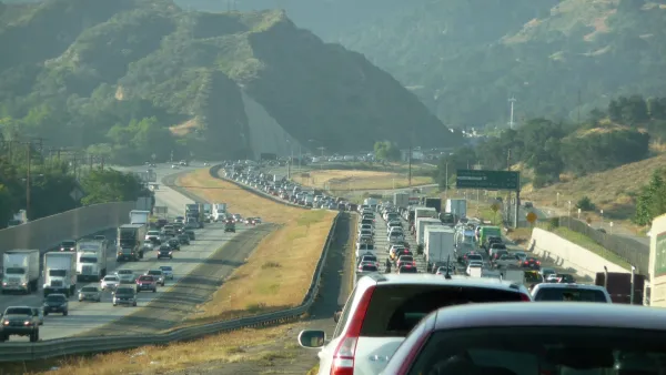
Those who thought peak VMT was in the rear view mirror will be disappointed in new data from the Federal Highway Administration.
"Vehicle miles traveled (VMT) reached a record 987.8 billion for the first four months of the year," writes the American Association of State Highway Transportation Officials Journal editor. "The previous record for January through April of any year was 965.5 billion VMT, set in 2007."
With the record one-month estimate for April reaching nearly 270 billion miles, VMT will have increased "14 months in a row [since March 2014], as vehicles put more traffic demand on the nation's road and bridge network," according to AASHTO. "The FHWA said that volume growth underscores 'the need for greater investment in transportation infrastructure.'"
VMT data is not population-adjusted
As Planetizen blogger Steven Polzin, of the Center for Urban Transportation Research at the University of South Florida acknowledged in his April post about 2014 VMT data, it's important to take into account increased population. "With 17 million more people, VMT per capita remains below peak levels."
That conclusion was affirmed earlier in September 2014 and May 2014 posts showing that VMT was at "another new post-Financial Crisis low...if we factor in population growth [and] the civilian population-adjusted data (age 16-and-over)."
Where traffic is on the rise, and where it isn't
According to FHWA's press release, "At 60.9 billion unadjusted VMT, traffic in the West – 13 states including Alaska and Hawaii – was the nation's most-traveled region for the second consecutive month, and the 19th month in a row of VMT growth. The Northeast, a region of nine states stretching from Maine to New Jersey, showed the smallest growth – rising only 2.4 percent, or 37 billion VMT, compared to the same month a year earlier." The total April increase was 3.7 percent compared to April 2014.
"The complete VMT data is available in the FHWA's "Traffic Volume Trends" reports, based on information collected from more than 4,800 continuous count stations nationwide," adds AASHTO.
FULL STORY: FHWA Says Driving Volumes Set Records for April, First Four Months of Any Year

April FHWA Report Shows Americans Continue to Drive More
There is good news in the most recent Federal Highway Administration Travel Trends report—if you look hard enough.

Peak Driving Record Shattered
So long 2007. Hello 2014. According to new DOT data, peak driving is no longer in the rear view mirror but ahead of us thanks to cheap gas getting even cheaper, the rebound effect, an improved economy, and warmer weather.

Gas Prices and Vehicle Miles Traveled Analyzed Since 2000
Urban economist Joe Cortright examines the connection between gas prices and driving in the U.S. over the last two decades. Prices matter: increased gas prices results in decreased driving, providing the prices persist for the long-term.

National Parks Layoffs Will Cause Communities to Lose Billions
Thousands of essential park workers were laid off this week, just before the busy spring break season.

Retro-silient?: America’s First “Eco-burb,” The Woodlands Turns 50
A master-planned community north of Houston offers lessons on green infrastructure and resilient design, but falls short of its founder’s lofty affordability and walkability goals.

Delivering for America Plan Will Downgrade Mail Service in at Least 49.5 Percent of Zip Codes
Republican and Democrat lawmakers criticize the plan for its disproportionate negative impact on rural communities.

Test News Post 1
This is a summary

Test News Headline 46
Test for the image on the front page.

Balancing Bombs and Butterflies: How the National Guard Protects a Rare Species
The National Guard at Fort Indiantown Gap uses GIS technology and land management strategies to balance military training with conservation efforts, ensuring the survival of the rare eastern regal fritillary butterfly.
Urban Design for Planners 1: Software Tools
This six-course series explores essential urban design concepts using open source software and equips planners with the tools they need to participate fully in the urban design process.
Planning for Universal Design
Learn the tools for implementing Universal Design in planning regulations.
EMC Planning Group, Inc.
Planetizen
Planetizen
Mpact (formerly Rail~Volution)
Great Falls Development Authority, Inc.
HUDs Office of Policy Development and Research
NYU Wagner Graduate School of Public Service