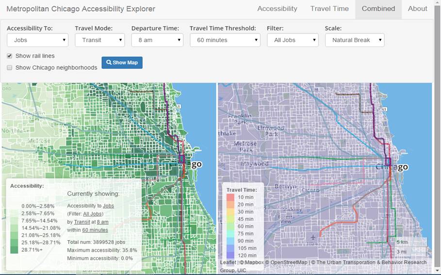
The Urban Accessibility Explorer is an easy-to-use mapping system that measures the number of activities that can be reached by residents of specified neighborhoods within a given amount of travel time, by a particular mode and time of day.

(Updated 04/16/2015) The Metropolitan Chicago Accessibility Explorer is an easy-to-use mapping system that measures the number of activities, including various types of jobs, schools, parks, stores and libraries, that can be reached by residents of specified neighborhoods within a given amount of travel time, by a particular mode and time of day in the Chicago Metropolitan area. The results are displayed on maps that can be adjusted by scale and area. The Accessibility Explorer was developed by the Urban Transportation Center, which is a unit of the College of Urban Planning and Public Affairs at the University of Illinois at Chicago help policy makers, planners, and the general public easily evaluate how transportation system and land use change could alter accessibility.

This is an example of a new class of accessibility-based mapping tools, which also includes WalkScore and TransitScore, and the Access To Jobs Mapping System developed by the Regional Planning Association in the New York City region.
These tools help apply accessibility-based planning, which recognizes that the ultimate goal of most transport activity is access to goods and services, and that many factors can affect accessibility including the convenience, speed, and affordability of travel by various modes, transport network connectivity, land use density, and mix, and mobility substitutes such as telecommunications and delivery services.
(The post was updated to give proper credit to the developers of the app.)
FULL STORY: Metropolitan Chicago Accessibility Explorer

National Parks Layoffs Will Cause Communities to Lose Billions
Thousands of essential park workers were laid off this week, just before the busy spring break season.

Retro-silient?: America’s First “Eco-burb,” The Woodlands Turns 50
A master-planned community north of Houston offers lessons on green infrastructure and resilient design, but falls short of its founder’s lofty affordability and walkability goals.

Delivering for America Plan Will Downgrade Mail Service in at Least 49.5 Percent of Zip Codes
Republican and Democrat lawmakers criticize the plan for its disproportionate negative impact on rural communities.

Test News Post 1
This is a summary

Test News Headline 46
Test for the image on the front page.

Balancing Bombs and Butterflies: How the National Guard Protects a Rare Species
The National Guard at Fort Indiantown Gap uses GIS technology and land management strategies to balance military training with conservation efforts, ensuring the survival of the rare eastern regal fritillary butterfly.
Urban Design for Planners 1: Software Tools
This six-course series explores essential urban design concepts using open source software and equips planners with the tools they need to participate fully in the urban design process.
Planning for Universal Design
Learn the tools for implementing Universal Design in planning regulations.
EMC Planning Group, Inc.
Planetizen
Planetizen
Mpact (formerly Rail~Volution)
Great Falls Development Authority, Inc.
HUDs Office of Policy Development and Research
NYU Wagner Graduate School of Public Service


