


Better Cities & Towns gives its imprimatur to the "narrower is better" approach to lane width for traffic safety thanks to a study by Toronto transportation planner, Dewan Masud Karim, presented at the Canadian ITE annual conference.
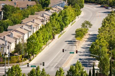
"Another study recently published supports 10-foot travel lanes over the 12-foot common practice on medium- and high-volume urban thoroughfares," writes Robert Steuteville, editor and executive director of Better Cities & Towns. "Planner and Walkable City author Jeff Speck wrote an article [posted here] last fall stating that state DOTs and county road commissions 'have blood on their hands' for building over-wide lanes in urban areas."
"The evidence cited by Speck on the safety hazards of wider lanes is powerful, though to date it remains pretty scarce," writes Eric Jaffe in CityLab. The evidence just got thicker thanks to Dewan Masud Karim, a senior transportation planner in Toronto and adjunct lecturer at Metro College of Technology, Toronto.
Karim looked at lanes in Toronto and Tokyo, specifically at crash data associated at randomly chosen intersections. He "found that collision rates escalate as lane widths exceed about 10.5 feet," wrote Planetizen blogger Todd Litman on the study in June, prior to its presentation to the Canadian Institute of Transportation Engineers' annual conference.
Steuteville adds that "Chris McCahill of the State Smart Transportation Initiative summarizes the new study in this way:"
Side impact- and turn-related crash rates are lowest at intersections where average lane widths are between 10 and 10.5 feet...This challenges the long-held, but often disputed, assumption that wider lanes are safer.
According to a 2010 study published in the ITE Journal, six states require a minimum of 12-foot lanes and another 24 states require 11-foot lanes.
"The latest research clearly shows that 10-foot lanes are worth fighting for on major urban thoroughfares," concludes Steuteville.
Toronto has since embarked on a program to narrow lane widths, in part due to Speck's earlier work, notes Planetizen managing editor James Brasuell.
Hat tip: Len Conly, Sierra Club Green Transportation listserv.
FULL STORY: Over-wide streets? You may regret it


City Liable For Cyclist's Death Due to Poor Road Design
Road diets, whereby the number of traffic lanes are reduced to better accommodate cyclists, can be controversial. But what of the opposite—adding lanes to better accommodate motorists? A cyclist died after such an "improvement." A lawsuit followed.
Toronto to Narrow its Traffic Lanes
Toronto will begin rolling out a program to narrow traffic lanes on the city's streets. The new lane policy, recently completed, was in the works for the past year.

Has Progress on Travel Safety Run Off the Road?
Changing technology and rebuilding infrastructure to improve road safety are long-term strategies. How can enforcement and interventions that influence driver behavior make a difference in reducing traffic deaths sooner?

National Parks Layoffs Will Cause Communities to Lose Billions
Thousands of essential park workers were laid off this week, just before the busy spring break season.

Retro-silient?: America’s First “Eco-burb,” The Woodlands Turns 50
A master-planned community north of Houston offers lessons on green infrastructure and resilient design, but falls short of its founder’s lofty affordability and walkability goals.

Delivering for America Plan Will Downgrade Mail Service in at Least 49.5 Percent of Zip Codes
Republican and Democrat lawmakers criticize the plan for its disproportionate negative impact on rural communities.

Test News Post 1
This is a summary

Test News Headline 46
Test for the image on the front page.

Balancing Bombs and Butterflies: How the National Guard Protects a Rare Species
The National Guard at Fort Indiantown Gap uses GIS technology and land management strategies to balance military training with conservation efforts, ensuring the survival of the rare eastern regal fritillary butterfly.
Urban Design for Planners 1: Software Tools
This six-course series explores essential urban design concepts using open source software and equips planners with the tools they need to participate fully in the urban design process.
Planning for Universal Design
Learn the tools for implementing Universal Design in planning regulations.
EMC Planning Group, Inc.
Planetizen
Planetizen
Mpact (formerly Rail~Volution)
Great Falls Development Authority, Inc.
HUDs Office of Policy Development and Research
NYU Wagner Graduate School of Public Service