


A new resource created by the National Oceanic and Atmospheric Administration in partnership with the APA makes it easier for planners to access the data necessary to plan for climate adaptation, sea level rise, and other forms of coastal resilience.
The National Oceanic and Atmospheric Administration has created a resource called Digital Coast, which "hosts freely available data on coastal hazards, along with a lot of site-specific local data, as well as the training, tools, and resources needed to turn these data into useful information," according to a post on the APA Policy News blog.
"Developed by NOAA’s Office for Coastal Management, with support from partnership organizations such as the APA, the Digital Coast is an enabling platform that assists users in analyzing coastal vulnerability, simulating projections of impacts, creating publishable visualizations and “snapshots” of potential future scenarios, and more. Digital Coast tools and data that are directly focused on climate adaptation and hazard planning include the Sea Level Rise Viewer, the Coastal Flood Exposure Mapper, and high resolution elevation datasets (derived from Light Detection and Ranging, or LiDAR)."
The article includes more insight into the resources provided by Digital Coast and other partnerships with NOAA and APA divisions.
FULL STORY: Digital Coast Helps Planners Build Hazard Resilient Communities


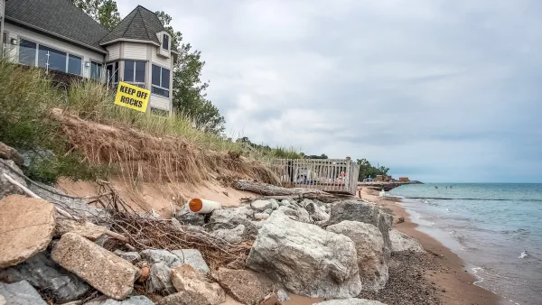
Connecticut Shoreline Rail Vulnerable to Floods
Long stretches of Connecticut's "lifeblood" shoreline rail line lie in the path of rising seas and future floods. While moving the tracks further inland is prohibitively expensive, a resilience plan is still needed.
How US Cities Can Prepare for Climate Disasters
Resilience, encompassing infrastructure, governance, economic strength, and social cohesion, is critical for cities to mitigate rising climate risks like flooding, wildfires, and heat, ensuring long-term recovery and adaptability.

NOAA Awards $575M in Coastal Resilience Grants
The program received over $16 billion in requests from communities around the country.

National Parks Layoffs Will Cause Communities to Lose Billions
Thousands of essential park workers were laid off this week, just before the busy spring break season.

Retro-silient?: America’s First “Eco-burb,” The Woodlands Turns 50
A master-planned community north of Houston offers lessons on green infrastructure and resilient design, but falls short of its founder’s lofty affordability and walkability goals.

Delivering for America Plan Will Downgrade Mail Service in at Least 49.5 Percent of Zip Codes
Republican and Democrat lawmakers criticize the plan for its disproportionate negative impact on rural communities.

Test News Post 1
This is a summary

Test News Headline 46
Test for the image on the front page.

Balancing Bombs and Butterflies: How the National Guard Protects a Rare Species
The National Guard at Fort Indiantown Gap uses GIS technology and land management strategies to balance military training with conservation efforts, ensuring the survival of the rare eastern regal fritillary butterfly.
Urban Design for Planners 1: Software Tools
This six-course series explores essential urban design concepts using open source software and equips planners with the tools they need to participate fully in the urban design process.
Planning for Universal Design
Learn the tools for implementing Universal Design in planning regulations.
EMC Planning Group, Inc.
Planetizen
Planetizen
Mpact (formerly Rail~Volution)
Great Falls Development Authority, Inc.
HUDs Office of Policy Development and Research
NYU Wagner Graduate School of Public Service