


Currently in its early stages, Project Sunroof tracks how much sun every roof receives. Then it estimates the costs and savings if rooftop solar were installed. Right now, the tool only covers the Bay Area, Fresno, and Boston.
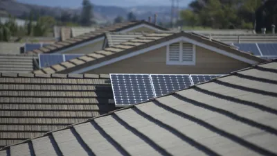
Google wants to make it easier for homeowners to think about going solar. A new map-based tool, Project Sunroof, lets users check whether their home (or any other structure within the coverage area) gets enough sunlight to warrant solar installation. Then it estimates costs and savings. In its current stage, the tool only covers the Bay Area, Fresno, and Boston.
Once you look up an address, "you can fine-tune the estimate to figure out whether solar panels on your roof make financial sense, by plugging in your monthly electric bill, choosing a financing option (leasing versus loans versus buying), and so forth."
Project Sunroof's estimates take local circumstances into account. "California, for instance, has high electricity prices, which means there are bigger potential savings from installing rooftop solar. The tool also factors in various regional policy incentives — like state tax incentives, local rebates, and what kind of net metering rules a state has [...]"
The article discusses how residents of multi-family dwellings can take advantage of community solar. "These are programs in which people who don't own suitable roofs can agree to 'subscribe' to electricity from a solar PV project elsewhere. They then pay a monthly charge that appears on their utility bill."
FULL STORY: Are solar panels right for you? Google's new mapping tool can help you decide


Mapping Rooftop Solar to Make It a Social Norm
Debuted in 2015, Google's Project Sunroof is designed make it easier for homeowners to go solar. Now the tool is harnessing peer pressure to "create a social norm" around solar.
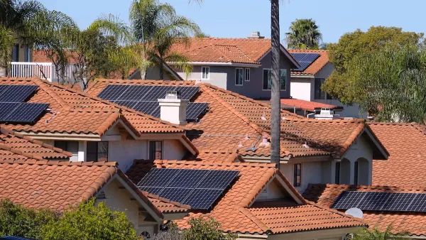
California Leads in Solar Rooftops
A combination of state and local incentives and building code mandates has helped California far outpace other states in residential rooftop solar permits.
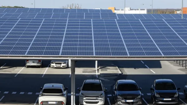
Commercial Buildings, Parking Lots Offer Significant Potential for Solar Energy
Massive swaths of flat rooftops, garages, and surface parking lots go underutilized. They could be producing renewable energy.

National Parks Layoffs Will Cause Communities to Lose Billions
Thousands of essential park workers were laid off this week, just before the busy spring break season.

Retro-silient?: America’s First “Eco-burb,” The Woodlands Turns 50
A master-planned community north of Houston offers lessons on green infrastructure and resilient design, but falls short of its founder’s lofty affordability and walkability goals.

Delivering for America Plan Will Downgrade Mail Service in at Least 49.5 Percent of Zip Codes
Republican and Democrat lawmakers criticize the plan for its disproportionate negative impact on rural communities.

Test News Post 1
This is a summary

Test News Headline 46
Test for the image on the front page.

Balancing Bombs and Butterflies: How the National Guard Protects a Rare Species
The National Guard at Fort Indiantown Gap uses GIS technology and land management strategies to balance military training with conservation efforts, ensuring the survival of the rare eastern regal fritillary butterfly.
Urban Design for Planners 1: Software Tools
This six-course series explores essential urban design concepts using open source software and equips planners with the tools they need to participate fully in the urban design process.
Planning for Universal Design
Learn the tools for implementing Universal Design in planning regulations.
EMC Planning Group, Inc.
Planetizen
Planetizen
Mpact (formerly Rail~Volution)
Great Falls Development Authority, Inc.
HUDs Office of Policy Development and Research
NYU Wagner Graduate School of Public Service