


"Portlandness: A Cultural Atlas" exemplifies the powers of maps to reshape and redefine our communities. Just watch how they can change expectations about the culture of the city infamously known as "Portlandia."

Steve Duin reports on a new book by Hunter Shobe, called Portlandness: A Cultural Atlas. The book is guided by the principle that "we have unique ways to illustrate the city's enduring and evolving space."
Among the maps included in the book: a map of all the surveillance cameras in the city, and "path of least surveillance" through them all. It also "maps ghost sightings, the most treacherous sidewalks in the Pearl, the city's original ethnic enclaves, the red-lining of Alberta, and the impact of surging property values along North Mississippi Avenue."
Also included in the book is a map created by a class of third graders from Jason Lee K-8. The class selected 82nd Avenue as the center of the city—an area that isn't really on the map for most Portlanders, but for these students, "it's an area rich in meaning," explains Shobe in the article. Shobe adds: "It forces us to re-imagine a place we think we know really well."
FULL STORY: Steve Duin: The coolest maps of Portland you've ever seen

Mapping the Pacific Northwest's Changing Population
The Oregonian has published a new interactive mapping feature that allows users to map demographic changes to the Census tract level through Oregon and Washington.
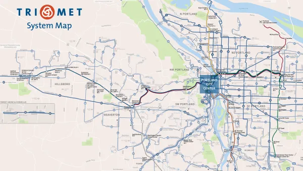
How to Design a Better Bus Transit Map
Not all transit maps are created equal. The new Portland TriMet map, for instance, does a much better job of illustrating the usefulness of its high-frequency network.

Portland Transportation Bureau Faces ‘Existential’ Cuts
PBOT’s director says the agency’s impending budget shortfall could imperil even basic transportation and infrastructure services.

National Parks Layoffs Will Cause Communities to Lose Billions
Thousands of essential park workers were laid off this week, just before the busy spring break season.

Retro-silient?: America’s First “Eco-burb,” The Woodlands Turns 50
A master-planned community north of Houston offers lessons on green infrastructure and resilient design, but falls short of its founder’s lofty affordability and walkability goals.

Delivering for America Plan Will Downgrade Mail Service in at Least 49.5 Percent of Zip Codes
Republican and Democrat lawmakers criticize the plan for its disproportionate negative impact on rural communities.

Test News Post 1
This is a summary

Test News Headline 46
Test for the image on the front page.

Balancing Bombs and Butterflies: How the National Guard Protects a Rare Species
The National Guard at Fort Indiantown Gap uses GIS technology and land management strategies to balance military training with conservation efforts, ensuring the survival of the rare eastern regal fritillary butterfly.
Urban Design for Planners 1: Software Tools
This six-course series explores essential urban design concepts using open source software and equips planners with the tools they need to participate fully in the urban design process.
Planning for Universal Design
Learn the tools for implementing Universal Design in planning regulations.
EMC Planning Group, Inc.
Planetizen
Planetizen
Mpact (formerly Rail~Volution)
Great Falls Development Authority, Inc.
HUDs Office of Policy Development and Research
NYU Wagner Graduate School of Public Service