


A conceptual study released earlier this spring would add new options for alternative modes of transportation between the neighborhoods of Columbia Heights and Brookland in Washington, D.C.
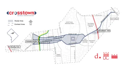
Kent Boese reports on the Crosstown Multimodal Transportation Study, completed recently by the District Department of Transportation, which develops a plan to build pedestrian and bike connections between Columbia Heights and Brookland.
The study "focuses on an area defined by Kenyon and Harvard Streets between 16th and Park Place; Irving Street and Michigan Avenue around the Washington Hospital Center; and Michigan Avenue from the hospital center to South Dakota Avenue," where cars "zip along" but people on bikes or on foot lack safe paths for travel.
After a public workshop that elicited almost 700 comments, DDOT released three concept plans for the corridor in April, according to Boese, as a result of the study. The article includes the pedestrian, bike, and transit improvements included in those three concepts—everything from removing the Michigan Avenue overpass, creating a new streetgrid, adding off-street and protected bike paths, and adding dedicated bus lanes.
FULL STORY: New bike lanes and dedicated bus lanes could connect Columbia Heights and Brookland

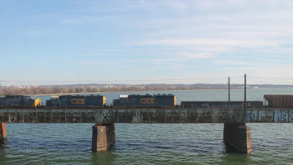
Key Virginia Rail Bridge Project Completes Environmental Review
A $1.9 billion project to add a second set of rail tracks to the Long Bridge that connects Virginia to D.C. is ready to move forward with a recently completed Environmental Impact Statement.
Key Planning Details of the Proposed $1.9 Billion Rail Bridge Between D.C. and Virginia
Analysis of the Draft Environmental Impact Statement for a project that would add an additional bridge to supplement the rail capacity of the Long Bridge over the Potomac River.
5 Transit Projects to Watch in the D.C. Region in 2020
Light rail, bus rapid transit, subway cell service, and more.

National Parks Layoffs Will Cause Communities to Lose Billions
Thousands of essential park workers were laid off this week, just before the busy spring break season.

Retro-silient?: America’s First “Eco-burb,” The Woodlands Turns 50
A master-planned community north of Houston offers lessons on green infrastructure and resilient design, but falls short of its founder’s lofty affordability and walkability goals.

Delivering for America Plan Will Downgrade Mail Service in at Least 49.5 Percent of Zip Codes
Republican and Democrat lawmakers criticize the plan for its disproportionate negative impact on rural communities.

Test News Post 1
This is a summary

Test News Headline 46
Test for the image on the front page.

Balancing Bombs and Butterflies: How the National Guard Protects a Rare Species
The National Guard at Fort Indiantown Gap uses GIS technology and land management strategies to balance military training with conservation efforts, ensuring the survival of the rare eastern regal fritillary butterfly.
Urban Design for Planners 1: Software Tools
This six-course series explores essential urban design concepts using open source software and equips planners with the tools they need to participate fully in the urban design process.
Planning for Universal Design
Learn the tools for implementing Universal Design in planning regulations.
EMC Planning Group, Inc.
Planetizen
Planetizen
Mpact (formerly Rail~Volution)
Great Falls Development Authority, Inc.
HUDs Office of Policy Development and Research
NYU Wagner Graduate School of Public Service