


Recently released flood maps created by FEMA for the city of New Orleans are receiving criticism for being 'overly optimistic' when it comes to risks posed by hurricanes and rising sea levels.
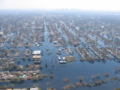
In an Op-Ed in The New York Times, Tulane University professor Andy Horowitz finds fault with the recently released flood maps for New Orleans that downplay risks in potentially vulnerable neighborhoods across the city. Horowitz writes that FEMA's original flood maps, drafted in 2009, were redrawn following complaints by New Orleans officials that they failed to take into account the new levee protections built after Hurricane Katrina. The new maps show no flood risks in many of the neighborhoods that flooded during Katrina, meaning homeowners in those neighborhoods no longer are required to buy flood insurance. Horowitz sees a potential catastrophe in the making.
[M]any of us will hold our breath through hurricane season nonetheless, because we know that the new maps reflect questionable assumptions. First, they assume that this time the Army Corps of Engineers’ work can be trusted, and the levee system will not fail again. ...a likely outcome of this new federal policy is that when — not if — New Orleans floods again, thousands of people will be worse off than they were during Hurricane Katrina: When their homes flood, they will not have flood insurance.
FULL STORY: New Orleans’s New Flood Maps: An Outline for Disaster

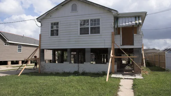
Louisiana Dials Back Requirements for Elevating Homes in Flood Areas
Housing market pressures, flood insurance costs, changing FEMA maps, and improved methods of flood control are giving victims of flood damage in Louisiana mixed signals on how high they should rebuild their homes.
The Growing Role of Federal Government in Disaster Relief
As flooding, fires, and other disasters become more destructive, an effective response requires more resources than local governments can offer.

New Orleans Convent to Become Large Urban Wetland
Hurricane Katrina damaged a Catholic convent in New Orleans. Then the nuns spearheaded a project to transform the land into a wetland area that will protect the city from flooding in the future.

National Parks Layoffs Will Cause Communities to Lose Billions
Thousands of essential park workers were laid off this week, just before the busy spring break season.

Retro-silient?: America’s First “Eco-burb,” The Woodlands Turns 50
A master-planned community north of Houston offers lessons on green infrastructure and resilient design, but falls short of its founder’s lofty affordability and walkability goals.

Delivering for America Plan Will Downgrade Mail Service in at Least 49.5 Percent of Zip Codes
Republican and Democrat lawmakers criticize the plan for its disproportionate negative impact on rural communities.

Test News Post 1
This is a summary

Test News Headline 46
Test for the image on the front page.

Balancing Bombs and Butterflies: How the National Guard Protects a Rare Species
The National Guard at Fort Indiantown Gap uses GIS technology and land management strategies to balance military training with conservation efforts, ensuring the survival of the rare eastern regal fritillary butterfly.
Urban Design for Planners 1: Software Tools
This six-course series explores essential urban design concepts using open source software and equips planners with the tools they need to participate fully in the urban design process.
Planning for Universal Design
Learn the tools for implementing Universal Design in planning regulations.
EMC Planning Group, Inc.
Planetizen
Planetizen
Mpact (formerly Rail~Volution)
Great Falls Development Authority, Inc.
HUDs Office of Policy Development and Research
NYU Wagner Graduate School of Public Service