


A case study in New York's response to the Hurricane Sandy flooding in the neighborhoods of Coney Island and Gravesend.
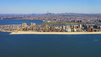
The New York Economic Development Corporation recently announced its release of the Coney Island Creek Resiliency Study, described as "a critical component to resiliency planning for the communities around Coney Island Creek."
"During Hurricane Sandy, Coney Island Creek was the main source of inundation for much of the Gravesend and Coney Island neighborhoods. Low edges and topography contributed to 'backdoor' flooding that caused enormous damage," according to the announcement.
The "study investigated several strategies to mitigate upland flooding, improve waterfront open space, strengthen neighborhood connections, enhance infrastructure, and provide opportunity for economic development around the Creek." A key finding of the study was the tie continued plans to study and plan for flood risk along the creek into broader regional efforts by the city and states of New York, along with the United States Army Corps of Engineers.
FULL STORY: Coney Island Creek Resiliency Study


Saving Lower Manhattan
A debate over how to protect the East River waterfront from Sandy-level flooding and storm damage has delayed the project as community activists decry the city's last-minute change of plans.

In Battery Park City, Public Infrastructure Meets Climate Resilience
A massive project underway in Lower Manhattan seeks to protect the shoreline from future flooding and mitigate the effects of climate change and rising sea levels.

Net Zero Development Coming to New York City
The project, which relies largely on geothermal energy to minimize its carbon footprint, will bring affordable housing and boost storm resilience to an area devastated by Hurricane Sandy.

National Parks Layoffs Will Cause Communities to Lose Billions
Thousands of essential park workers were laid off this week, just before the busy spring break season.

Retro-silient?: America’s First “Eco-burb,” The Woodlands Turns 50
A master-planned community north of Houston offers lessons on green infrastructure and resilient design, but falls short of its founder’s lofty affordability and walkability goals.

Delivering for America Plan Will Downgrade Mail Service in at Least 49.5 Percent of Zip Codes
Republican and Democrat lawmakers criticize the plan for its disproportionate negative impact on rural communities.

Test News Post 1
This is a summary

Test News Headline 46
Test for the image on the front page.

Balancing Bombs and Butterflies: How the National Guard Protects a Rare Species
The National Guard at Fort Indiantown Gap uses GIS technology and land management strategies to balance military training with conservation efforts, ensuring the survival of the rare eastern regal fritillary butterfly.
Urban Design for Planners 1: Software Tools
This six-course series explores essential urban design concepts using open source software and equips planners with the tools they need to participate fully in the urban design process.
Planning for Universal Design
Learn the tools for implementing Universal Design in planning regulations.
EMC Planning Group, Inc.
Planetizen
Planetizen
Mpact (formerly Rail~Volution)
Great Falls Development Authority, Inc.
HUDs Office of Policy Development and Research
NYU Wagner Graduate School of Public Service