


In a new brief, Penn IUR Faculty Fellow Richard Weller writes about mapping that recognizes the interdependence of people and conservation.
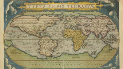
On May 20, 1570, Abraham Ortelius—book collector and engraver from Antwerp—published the world’s first Atlas: the Theatrum Orbis Terrarum (Theater of the World). With his maps Ortelius laid bare a world of healthy ecoregions ripe for exploitation. Some 450 years later, at the opposite end of modernity to Ortelius, researchers at Penn Design are building the Atlas for the End of the World— an atlas about the end of Ortelius’ world, the end of the world as a God-given and unlimited resource for human exploitation and its concomitant myths of progress.
The Atlas shows the difference between the United Nations Convention on Biological Diversity targets for achieving 17 percent global terrestrial area as protected habitat by 2020 and what is actually now protected. A new Penn IUR brief, Atlas For the End of the World: Mapping that Recognizes the Interdependence of People and Conservation, describes the measurement efforts to meet these targets by 1) mapping protected areas in the ecoregions within world’s biodiversity hotspots and calculating how much remains to meet targets, and 2) demonstrating the coming conflicts between projected city growth and biologically diverse habitat.
FULL STORY: Atlas for the End of the World


Retro-silient?: America’s First “Eco-burb,” The Woodlands Turns 50
A master-planned community north of Houston offers lessons on green infrastructure and resilient design, but falls short of its founder’s lofty affordability and walkability goals.

Rethinking Suburban Development: New Trends in Creating Livable Communities
Discover new trends in suburban development focused on creating more livable, sustainable communities for future growth.

A Sustainable Future for LA: Updating the OurCounty Plan
Los Angeles County is updating its Sustainability Plan to refine its vision for climate action, environmental justice, and community well-being, with residents encouraged to participate by taking the OurCounty 2025 Update Community Survey.

Analysis: Cybertruck Fatality Rate Far Exceeds That of Ford Pinto
The Tesla Cybertruck was recalled seven times last year.

National Parks Layoffs Will Cause Communities to Lose Billions
Thousands of essential park workers were laid off this week, just before the busy spring break season.
Retro-silient?: America’s First “Eco-burb,” The Woodlands Turns 50
A master-planned community north of Houston offers lessons on green infrastructure and resilient design, but falls short of its founder’s lofty affordability and walkability goals.

Test News Post 1
This is a summary

Analysis: Cybertruck Fatality Rate Far Exceeds That of Ford Pinto
The Tesla Cybertruck was recalled seven times last year.

Test News Headline 46
Test for the image on the front page.
Urban Design for Planners 1: Software Tools
This six-course series explores essential urban design concepts using open source software and equips planners with the tools they need to participate fully in the urban design process.
Planning for Universal Design
Learn the tools for implementing Universal Design in planning regulations.
EMC Planning Group, Inc.
Planetizen
Planetizen
Mpact (formerly Rail~Volution)
Great Falls Development Authority, Inc.
HUDs Office of Policy Development and Research
NYU Wagner Graduate School of Public Service