


Comprehensive plans can be big and unwieldy. Luckily for Washington, D.C., there are two maps that unlock of the plan's meaning.
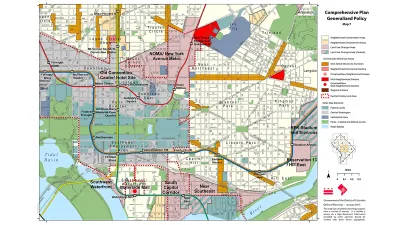
David Whitehead sifts through the 600 pages of the D.C. Comprehensive Plan and identifies the two maps that provide access to the plan's core ideas.
"DC has a giant planning document called the Comprehensive Plan. Most of it is super dense and complicated, but its goal is to lay the foundation for many city-wide decisions, in particular decisions on land use," explains Whitehead. "Partially because of its size and obscurity, many people just focus on two maps that exist as part of the Comp Plan: the Future Land Use Map (FLUM), and the Generalized Policy Map."
Whitehead then digs into both of the two maps, illuminating the key ideas that will help guide an understanding of these already most accessible parts of the D.C. Comprehensive Plan.
But then, there's a caveat. According to Whitehead, "[t]here's one big issue with both of these maps: they tend to preserve the status quo—more specifically, the status quo of 2006, which is when the Comp Plan was created." Luckily, Whitehead reports that the D.C. Office of Planning is "organizing an effort to amend and update the Comprehensive Plan."
FULL STORY: These two maps are the guides to your neighborhood's future. Here's what you should know about them.


D.C. Comprehensive Plan Update Needs Equity Improvements, Report Says
The new D.C. Office of Equity has produced an evaluation of proposed changes to the D.C. Comprehensive Plan.

Comprehensive Plan Update Stokes Controversy in D.C.
Complex political dynamics are mustering for a showdown over D.C.'s comprehensive plan.
Why Have ADUs Proliferated in Portland, Lagged in D.C.?
A new report by the Urban Institute examines the consequences of small differences in land use regulations.

Analysis: Cybertruck Fatality Rate Far Exceeds That of Ford Pinto
The Tesla Cybertruck was recalled seven times last year.

National Parks Layoffs Will Cause Communities to Lose Billions
Thousands of essential park workers were laid off this week, just before the busy spring break season.

Retro-silient?: America’s First “Eco-burb,” The Woodlands Turns 50
A master-planned community north of Houston offers lessons on green infrastructure and resilient design, but falls short of its founder’s lofty affordability and walkability goals.

Test News Post 1
This is a summary

Analysis: Cybertruck Fatality Rate Far Exceeds That of Ford Pinto
The Tesla Cybertruck was recalled seven times last year.

Test News Headline 46
Test for the image on the front page.
Urban Design for Planners 1: Software Tools
This six-course series explores essential urban design concepts using open source software and equips planners with the tools they need to participate fully in the urban design process.
Planning for Universal Design
Learn the tools for implementing Universal Design in planning regulations.
EMC Planning Group, Inc.
Planetizen
Planetizen
Mpact (formerly Rail~Volution)
Great Falls Development Authority, Inc.
HUDs Office of Policy Development and Research
NYU Wagner Graduate School of Public Service