


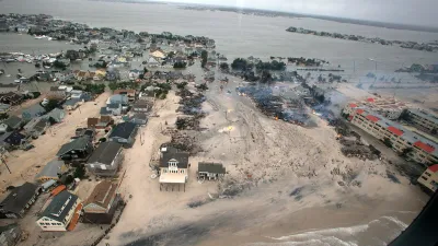
A report from the Regional Plan Association maps out what might happen under 1, 3, and 6 feet of sea level rise. In the worst cases, several dense and populated regions are affected.
Using methodology developed by the National Oceanic and Atmospheric Administration, RPA's study "outlines the impact that 1, 3 and 6 feet of sea level rise could have on the [New York] region and the immediate actions that policymakers and residents should take to protect our region's most vulnerable places."
While beach communities along Long Island and the Jersey Shore often come to mind, flooding could impact populated areas throughout greater New York. Emily Thenhaus writes, "The communities of the Rockaways, Jamaica Bay and Coney Island are among the most threatened in New York City. With 6 feet of sea level rise, a possibility as soon as early next century, much of the Rockaway peninsula could be underwater."
Rising seas may also threaten the New Jersey Meadowlands if steps aren't taken. JFK airport is mostly protected from the brunt of the floods, but LaGuardia's runways are vulnerable.
There's more to come from RPA on the region's environmental future. "The study is a component of RPA's fourth regional plan, which will be released in 2017 and will put forth policies and proposals to mitigate climate change and confront its effects."
FULL STORY: Under Water: How Sea Level Rise Threatens the Tri-State Region

Life With Climate Change: A 100-Year Storm Every Year
The extreme weather events and sea-level rise of the relatively near future will overwhelm storm and flood infrastructure with startling regularity, according to new research.
New York Flood Control Plan Takes Lessons From the Dutch
The Netherlands has a long history of flood mitigation. U.S. cities, threatened by coastal flooding and erosion, are taking note.
Opinion: One Solution to Manhattan's Land Shortage: Just Build It
A New York Times op-ed calls on the city to add landfill development on Manhattan's southern shoreline, claiming it would increase affordability and protect the city from rising sea levels.

Analysis: Cybertruck Fatality Rate Far Exceeds That of Ford Pinto
The Tesla Cybertruck was recalled seven times last year.

National Parks Layoffs Will Cause Communities to Lose Billions
Thousands of essential park workers were laid off this week, just before the busy spring break season.

Retro-silient?: America’s First “Eco-burb,” The Woodlands Turns 50
A master-planned community north of Houston offers lessons on green infrastructure and resilient design, but falls short of its founder’s lofty affordability and walkability goals.

Test News Post 1
This is a summary

Analysis: Cybertruck Fatality Rate Far Exceeds That of Ford Pinto
The Tesla Cybertruck was recalled seven times last year.

Test News Headline 46
Test for the image on the front page.
Urban Design for Planners 1: Software Tools
This six-course series explores essential urban design concepts using open source software and equips planners with the tools they need to participate fully in the urban design process.
Planning for Universal Design
Learn the tools for implementing Universal Design in planning regulations.
EMC Planning Group, Inc.
Planetizen
Planetizen
Mpact (formerly Rail~Volution)
Great Falls Development Authority, Inc.
HUDs Office of Policy Development and Research
NYU Wagner Graduate School of Public Service