


A smart city pilot project, already in place at three locations in Chicago and on the way to two more, deploys sophisticated data gathering technology to measure the simple act of rainwater running downhill. Better green infrastructure will follow.
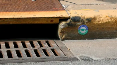
Sean Thornton reports: "By combining sensors and cloud computing, a new pilot project in Chicago provides an innovative solution for what can be an everyday urban problem: rainwater."
"Launched by City Digital, a smart city incubator located within the consortium of public, private, and higher education entities that is UI Labs, the Smart Green Infrastructure Monitoring (SGIM) project aims to provide cities with a tool to reduce urban flooding and prevent millions of dollars in subsequent property damage," adds Thornton.
The sensors deployed at the SGIM sites hope to collect data that will help planners and engineers better plan and manage green infrastructure.
For example, Argyle Street, the city's first shared street, boasting some of the city's newest permeable paving, provides one of the test sites for the SGIM project. "Underneath Argyle Street, City Digital and its partners have installed sensors to collect stormwater runoff data. These sensors can record, among other things, precipitation amounts, humidity levels, soil moisture measurements, air pressure levels, and chemical absorption rates," reports Thornton.
SGIM's data is expected to be publicly available on the city's data portal in 2017. The article includes more detail about City Digital, the SGIM project in particular, and stormwater infrastructure more generally.
FULL STORY: How a Smart City Tackles Rainfall

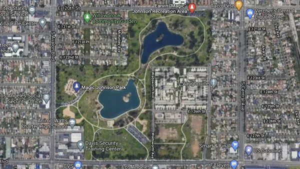
South Los Angeles Park Offers Hidden Benefits
Not only does the redevelopment of a large section of Earvin Magic Johnson Park in Willowbrook offer much needed green space and new amenities, it also helps to conserve water and improve water quality.

FYI about GSI: The Recipe for Green Stormwater Infrastructure Success
New research highlights some of the ways planners can increase the social benefits and public acceptance of green stormwater infrastructure.
Stormwater Credits Provide Incentives for Green Infrastructure
Most harmful stormwater originates on private property, and public agencies are looking for ways to entice property owners to implement more effective infrastructure.

National Parks Layoffs Will Cause Communities to Lose Billions
Thousands of essential park workers were laid off this week, just before the busy spring break season.

Retro-silient?: America’s First “Eco-burb,” The Woodlands Turns 50
A master-planned community north of Houston offers lessons on green infrastructure and resilient design, but falls short of its founder’s lofty affordability and walkability goals.

Delivering for America Plan Will Downgrade Mail Service in at Least 49.5 Percent of Zip Codes
Republican and Democrat lawmakers criticize the plan for its disproportionate negative impact on rural communities.

Test News Post 1
This is a summary

Test News Headline 46
Test for the image on the front page.

Balancing Bombs and Butterflies: How the National Guard Protects a Rare Species
The National Guard at Fort Indiantown Gap uses GIS technology and land management strategies to balance military training with conservation efforts, ensuring the survival of the rare eastern regal fritillary butterfly.
Urban Design for Planners 1: Software Tools
This six-course series explores essential urban design concepts using open source software and equips planners with the tools they need to participate fully in the urban design process.
Planning for Universal Design
Learn the tools for implementing Universal Design in planning regulations.
EMC Planning Group, Inc.
Planetizen
Planetizen
Mpact (formerly Rail~Volution)
Great Falls Development Authority, Inc.
HUDs Office of Policy Development and Research
NYU Wagner Graduate School of Public Service