


The "Monitoring Global Urban Expansion Program" gathers and analyzes data on 200 cities around the world. The "Atlas of Urban Expansion" presents the program's preliminary results.

FULL STORY: Atlas of Urban Expansion

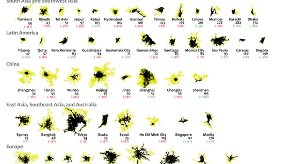
Mapping 25 Years of Urban Expansion
What comparing 25 years of urban expansion on six continents reveals about the changing nature of the built environment.
United Nations Taking First Steps Toward the New Urban Agenda
Some of the big work left undone by the Habitat III summit in finalizing the New Urban Agenda in December is now moving forward. The future of the New Urban Agenda and UN-Habitat can now start to take shape.
A New Kind of Planning for a New Kind of Africa
Ernest Harsch interviews UN-Habitat Director Joan Clos on the challenges facing African cities in an age of unprecedented urbanization, from the abundance of slums to the threat of natural disasters.

National Parks Layoffs Will Cause Communities to Lose Billions
Thousands of essential park workers were laid off this week, just before the busy spring break season.

Retro-silient?: America’s First “Eco-burb,” The Woodlands Turns 50
A master-planned community north of Houston offers lessons on green infrastructure and resilient design, but falls short of its founder’s lofty affordability and walkability goals.

Delivering for America Plan Will Downgrade Mail Service in at Least 49.5 Percent of Zip Codes
Republican and Democrat lawmakers criticize the plan for its disproportionate negative impact on rural communities.

Test News Post 1
This is a summary

Test News Headline 46
Test for the image on the front page.

Balancing Bombs and Butterflies: How the National Guard Protects a Rare Species
The National Guard at Fort Indiantown Gap uses GIS technology and land management strategies to balance military training with conservation efforts, ensuring the survival of the rare eastern regal fritillary butterfly.
Urban Design for Planners 1: Software Tools
This six-course series explores essential urban design concepts using open source software and equips planners with the tools they need to participate fully in the urban design process.
Planning for Universal Design
Learn the tools for implementing Universal Design in planning regulations.
EMC Planning Group, Inc.
Planetizen
Planetizen
Mpact (formerly Rail~Volution)
Great Falls Development Authority, Inc.
HUDs Office of Policy Development and Research
NYU Wagner Graduate School of Public Service