


In an ambitious plan dating back to the early 20th century, some Chicagoans want to build out park space over Lake Shore Drive's Oak Street S-bend. The project wouldn't be a straightforward one.

Chicago's Lake Shore Drive, one example of America's many waterside urban thoroughfares, just might find itself tunneling under 70 acres of new park space. 2nd Ward Alderman Brian Hopkins, among others, is championing a plan to redo the roadway as it curves past Oak Street Beach just north of downtown.
Jay Koziarz writes, "At its heart, the plan would straighten out and bury Lake Shore Drive's tight and dangerous Oak Street S-bend and would provide unfettered pedestrian access to 70 acres of newly created lakefront parkland, beaches, trails, and a breakwater island."
This is far from a done deal. The proposal is expensive and construction wouldn't likely begin until 2020. "With a price tag reaching as high as $500 million, the project would be hugely expensive and would require the cooperation of multiple local, state, and federal entities like the various Departments of Transportation and the United States Army Corps of Engineers."
FULL STORY: A look at the ambitious plan to bury Chicago’s Lake Shore Drive and create new park space


Bus Lanes, Desired by Advocates for Chicago's Lake Shore Drive Project, Back on the Table
After releasing a list of project alternatives that didn't include new bus lanes in the existing roadway, the Illinois Department of Transportation (IDOT) has changed its mind.
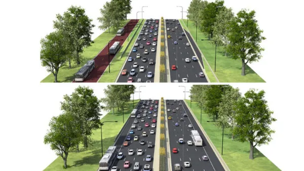
North Lake Shore Drive Redo Falls Short of Bus Priority Expectations
Strong criticisms of the project alternatives under consideration by the Illinois Department of Transportation for the closely watched North Lake Shore Drive project.
Lake Shore Drive Proposal Inspires Debate
Take a car lane or widen Lake Shore Drive? That's the question facing state and local officials in Chicago.

National Parks Layoffs Will Cause Communities to Lose Billions
Thousands of essential park workers were laid off this week, just before the busy spring break season.

Retro-silient?: America’s First “Eco-burb,” The Woodlands Turns 50
A master-planned community north of Houston offers lessons on green infrastructure and resilient design, but falls short of its founder’s lofty affordability and walkability goals.

Delivering for America Plan Will Downgrade Mail Service in at Least 49.5 Percent of Zip Codes
Republican and Democrat lawmakers criticize the plan for its disproportionate negative impact on rural communities.

Test News Post 1
This is a summary

Test News Headline 46
Test for the image on the front page.

Balancing Bombs and Butterflies: How the National Guard Protects a Rare Species
The National Guard at Fort Indiantown Gap uses GIS technology and land management strategies to balance military training with conservation efforts, ensuring the survival of the rare eastern regal fritillary butterfly.
Urban Design for Planners 1: Software Tools
This six-course series explores essential urban design concepts using open source software and equips planners with the tools they need to participate fully in the urban design process.
Planning for Universal Design
Learn the tools for implementing Universal Design in planning regulations.
EMC Planning Group, Inc.
Planetizen
Planetizen
Mpact (formerly Rail~Volution)
Great Falls Development Authority, Inc.
HUDs Office of Policy Development and Research
NYU Wagner Graduate School of Public Service