


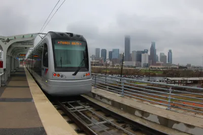
Will sprawling cities stay sprawled? Starting in their downtowns, some Sun Belt behemoths are embracing denser, more walkable forms.
Home to about one-sixth of the U.S. population, "sprawling cities" are small regional centers that ballooned out over the past 60 years into distinctly unwalkable suburban metropolises.
For CNU, Robert Steuteville identifies 25 such locations, characterized by their auto-dependent development patterns since 1950. "Because of the infrastructure and built patterns since 1950, only 6 percent of residents walk, bike, or take transit to work in sprawling cities. Because they are so automobile dependent, they impose much higher transportation costs on residents."
Located in the Sun Belt (and elsewhere in the nation's southern half), "sprawling cities are diverse places—about a third of the population is Hispanic. Average household income tops $54,000, which is about the same as traditional cities. Crime is relatively low in sprawling cities, although death and injury by automobile is higher than traditional cities."
Steuteville points to some signs that despite their unwieldy infrastructure, these cities are becoming more traditionally urban. "Downtowns of sprawling cities were among the first to revive. A prime example is Fort Worth, which rebuilt a walkable downtown over the course of two decades, culminating in the fabulous Sundance Square." Economically vibrant and affordable, "sprawling cities have the market strength to rebuild [old malls] as mixed-use centers."
FULL STORY: Sprawling cities are becoming more urban


Zoning for Good
A new book highlights the power of zoning to change communities for the better.
The Changing Shape of American Suburbs
Housing costs and availability are pushing more American households, including young families, to suburbs and exurbs — and they’re demanding changes.
A ‘New Urbanism’ Travelogue
I visited three New Urbanist developments in North Carolina. Here's what I liked, what I didn't like, and what I learned.

National Parks Layoffs Will Cause Communities to Lose Billions
Thousands of essential park workers were laid off this week, just before the busy spring break season.

Retro-silient?: America’s First “Eco-burb,” The Woodlands Turns 50
A master-planned community north of Houston offers lessons on green infrastructure and resilient design, but falls short of its founder’s lofty affordability and walkability goals.

Delivering for America Plan Will Downgrade Mail Service in at Least 49.5 Percent of Zip Codes
Republican and Democrat lawmakers criticize the plan for its disproportionate negative impact on rural communities.

Test News Post 1
This is a summary

Test News Headline 46
Test for the image on the front page.

Balancing Bombs and Butterflies: How the National Guard Protects a Rare Species
The National Guard at Fort Indiantown Gap uses GIS technology and land management strategies to balance military training with conservation efforts, ensuring the survival of the rare eastern regal fritillary butterfly.
Urban Design for Planners 1: Software Tools
This six-course series explores essential urban design concepts using open source software and equips planners with the tools they need to participate fully in the urban design process.
Planning for Universal Design
Learn the tools for implementing Universal Design in planning regulations.
EMC Planning Group, Inc.
Planetizen
Planetizen
Mpact (formerly Rail~Volution)
Great Falls Development Authority, Inc.
HUDs Office of Policy Development and Research
NYU Wagner Graduate School of Public Service