


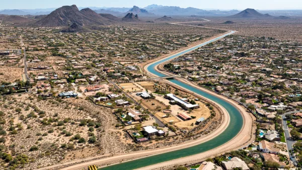
A new branch of the Lincoln Institute will focus on water planning, especially in the western United States.

The Lincoln Institute of Land Policy has launched the Babbitt Center for Land and Water Policy, a new think tank meant to integrate water and land-use planning. Based in Phoenix, the center's mission is to "advance water sustainability through improved land use planning, management and decision making."
The Babbitt Center will work at the local level with municipalities throughout the Colorado River Basin to "gather data, develop indicators, and build and test new tools for fair, efficient, and sustainable management of water resources," according to the announcement. For example:
An initial activity will be to develop a map, using satellite imagery, for selected tributaries of the Colorado River Basin. The aim is to provide a foundation – potentially scaled up to the entire basin, serving seven states and some 30 million people – that illustrates the relationship between land and water, and can be used for better projections, modeling, and scenario planning.
The Lincoln Institute is also adjusting its partnership with the Sonoran Institute—formerly known as Western Lands and Communities—to focus on local land-use planning and water management under the name Resilient Communities and Watersheds.
FULL STORY: Think tank aims to bolster water planning

New Map Deepens Understanding of Cross-Border Aquifers
A new analysis of U.S. and Mexico groundwater supplies reveals 72 aquifers shared between the two countries.

Local Solutions for Housing Affordability
The Lincoln Institute of Land Policy recently published a report to identify local government actions to ensure stable and affordable places to live for everyone.

A New Tool for More Flexible and Resilient Water Policies
A new book created by the Sonoran Institute explains how exploratory scenario planning can be useful to prepare for the uncertainty of water in the near- and long-term future.

National Parks Layoffs Will Cause Communities to Lose Billions
Thousands of essential park workers were laid off this week, just before the busy spring break season.

Retro-silient?: America’s First “Eco-burb,” The Woodlands Turns 50
A master-planned community north of Houston offers lessons on green infrastructure and resilient design, but falls short of its founder’s lofty affordability and walkability goals.

Delivering for America Plan Will Downgrade Mail Service in at Least 49.5 Percent of Zip Codes
Republican and Democrat lawmakers criticize the plan for its disproportionate negative impact on rural communities.

Test News Post 1
This is a summary

Test News Headline 46
Test for the image on the front page.

Balancing Bombs and Butterflies: How the National Guard Protects a Rare Species
The National Guard at Fort Indiantown Gap uses GIS technology and land management strategies to balance military training with conservation efforts, ensuring the survival of the rare eastern regal fritillary butterfly.
Urban Design for Planners 1: Software Tools
This six-course series explores essential urban design concepts using open source software and equips planners with the tools they need to participate fully in the urban design process.
Planning for Universal Design
Learn the tools for implementing Universal Design in planning regulations.
EMC Planning Group, Inc.
Planetizen
Planetizen
Mpact (formerly Rail~Volution)
Great Falls Development Authority, Inc.
HUDs Office of Policy Development and Research
NYU Wagner Graduate School of Public Service