


Fans of public transit rejoice. A new infographic explores the rolling stock of most of the major cities in the United States and Canada.
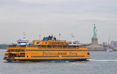
Benjamin Schneider shares news of the City Transit project, the work of public transit aficionado Peter Dovak.
The City Transit infographic offers a "meticulously detailed" illustration of every public transportation mode in 24 major North American cities, like Vancouver, Toronto, and Montreal in Canada, and everything from San Diego to Salt Lake City and the Twin Cities in the United States.
The City Transit project builds on Dovak's earlier effort, published in April 2016, that provided a field guide to all of the Metrobuses in operation in the Washington, D.C. region.
Here, Schneider explains the appeal of Dovak's most recent, geographically broad project:
The most striking thing about the transit vehicle infographics is the sheer variety of vehicle types, including ferries, driverless airport connectors, and several quirky local transit technologies, like Portland’s Aerial Tram, New York City’s Roosevelt Island Tramway, and Los Angeles’ Angel’s Flight, the adorably short funicular featured in La La Land (which will to reopen to the public after Labor Day).
FULL STORY: A Glorious Infographic of North America's Transit Fleets

What $454 Million in Bus Facility Funding Pays for in the United States
Spoiler alert: not much.
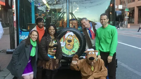
Friday Eye Candy: Cities Break Out the Festive Buses for the Holidays
Check out the holiday-themed buses rolling through the Southeastern Pennsylvania Transportation Authority and the Detroit Department of Transportation systems.

Buying American Is Making Infrastructure More Expensive, Study Finds
From train cars to buses, a new study finds that buying American adds cost.

National Parks Layoffs Will Cause Communities to Lose Billions
Thousands of essential park workers were laid off this week, just before the busy spring break season.

Retro-silient?: America’s First “Eco-burb,” The Woodlands Turns 50
A master-planned community north of Houston offers lessons on green infrastructure and resilient design, but falls short of its founder’s lofty affordability and walkability goals.

Delivering for America Plan Will Downgrade Mail Service in at Least 49.5 Percent of Zip Codes
Republican and Democrat lawmakers criticize the plan for its disproportionate negative impact on rural communities.

Test News Post 1
This is a summary

Test News Headline 46
Test for the image on the front page.

Balancing Bombs and Butterflies: How the National Guard Protects a Rare Species
The National Guard at Fort Indiantown Gap uses GIS technology and land management strategies to balance military training with conservation efforts, ensuring the survival of the rare eastern regal fritillary butterfly.
Urban Design for Planners 1: Software Tools
This six-course series explores essential urban design concepts using open source software and equips planners with the tools they need to participate fully in the urban design process.
Planning for Universal Design
Learn the tools for implementing Universal Design in planning regulations.
EMC Planning Group, Inc.
Planetizen
Planetizen
Mpact (formerly Rail~Volution)
Great Falls Development Authority, Inc.
HUDs Office of Policy Development and Research
NYU Wagner Graduate School of Public Service