


Parting shots from the Great American Eclipse.
"The Great American Eclipse has, as expected, turned into the Great American Traffic Snarl," according to an article by Douglas Perry. The proof is in the Google Maps: Perry posts a series of screengrabs to show the long red lines where traffic slowed to a standstill as the eclipse moved across the path of totality yesterday. First congestion came to Western Oregon, and then Eastern Oregon, and then Idaho and Wyoming, and so on.
For a perhaps more awe-inducing view of the eclipse, and maybe to wash the image of all that traffic from your mind, here's satellite imagery from GOES-16, showing the darkness of the eclipse moving across the continent.
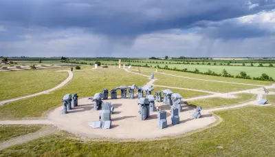
And as one last testament to the power of collective human reaction to the unfathomable scale of nature, we present the story of Carhenge, as detailed in an article by Bart Schaneman. "When Jim Reinders built Carhenge — a Stonehenge replica made out of classic American cars — it was decades before anyone was talking about the path of totality," according to Schaneman. The project was viewed with skepticism in Nebraska, where Carhenge was built, until the it became "one of the most talked-about destinations to view the eclipse in the entire country." It turns out, however, that Reinders never anticipated the Great American Eclipse.
FULL STORY: Epic traffic snarls follow 2017 eclipse totality path, Google Maps shows


How People Will See the Eclipse Today
A 33-year GIS professional lets loose his geospatial and population analysis skills on the occasion of a lifetime: today's "Great American Eclipse."
Is Trump’s Reversal of Congestion Pricing Legal?
Gov. Hochul says New York City will “keep its cameras on.” Can the administration legally end the nation's first cordon pricing program?

USDOT Revokes Approval for NYC Congestion Pricing
Despite the administration’s stated concern for the “working class,” 85 percent of Manhattan commuters use public transit to enter the city.

National Parks Layoffs Will Cause Communities to Lose Billions
Thousands of essential park workers were laid off this week, just before the busy spring break season.

Retro-silient?: America’s First “Eco-burb,” The Woodlands Turns 50
A master-planned community north of Houston offers lessons on green infrastructure and resilient design, but falls short of its founder’s lofty affordability and walkability goals.

Delivering for America Plan Will Downgrade Mail Service in at Least 49.5 Percent of Zip Codes
Republican and Democrat lawmakers criticize the plan for its disproportionate negative impact on rural communities.

Test News Post 1
This is a summary

Test News Headline 46
Test for the image on the front page.

Balancing Bombs and Butterflies: How the National Guard Protects a Rare Species
The National Guard at Fort Indiantown Gap uses GIS technology and land management strategies to balance military training with conservation efforts, ensuring the survival of the rare eastern regal fritillary butterfly.
Urban Design for Planners 1: Software Tools
This six-course series explores essential urban design concepts using open source software and equips planners with the tools they need to participate fully in the urban design process.
Planning for Universal Design
Learn the tools for implementing Universal Design in planning regulations.
EMC Planning Group, Inc.
Planetizen
Planetizen
Mpact (formerly Rail~Volution)
Great Falls Development Authority, Inc.
HUDs Office of Policy Development and Research
NYU Wagner Graduate School of Public Service