


The ongoing project aims to show how LGBT history is embedded throughout the city.

A collaboration of Washington University, the Missouri History Museum, the State Historical Society of Missouri, and the St. Louis LGBT History Project has launched Mapping LGBTQ St. Louis, an interactive online map documenting queer history across the city. Researchers identified 800 sites representing slices of queer life across a nearly 50-year period—including bars and nightclubs, bookstores, places of worship, HIV clinics, cruising spots, protest sites, and locations of police raids and arrests. Clicking on the markers brings up photographs, news clippings, and other background; a time-lapse view by decade is also available.
The site also offers a broader context for the project as a whole. "The distribution of LGBTQ space across metropolitan space wasn't random," researchers explain. "Instead, the geography of St. Louis's LGBTQ spaces has always been related to the region's history of racial segregation, socioeconomic inequality, suburbanization, and urban decline and renewal. St. Louis's LGBTQ history isn't somehow separate from the city's wider history—it's embedded in everything else."
The project accepts public feedback and will continue to grow, eventually representing Pride parades, same-sex marriage, and gay villages. For now, the St. Louis Post-Dispatch reports, it focuses on LGBT life in the city from 1945 ("the beginning of rapid demographic changes in the region") to 1992 ("the year the St. Louis Board of Aldermen passed an ordinance that prohibited discrimination in housing, education and employment because of race, age, religion, disability or sexual orientation.")
FULL STORY: St. Louis gay history unfolds on an interactive map


New Interactive Mapping Tool Tracks all of NYC's Infrastructure Projects, Housing Permits, and City Facilities
The New York Department of City Planning has taken its open data practices to a new level with the launch of the Capital Planning Explorer.
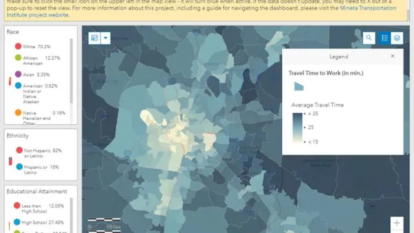
Smart Growth Loves Heatmaps
Smart growth can provide many important benefits that are easy to see using informative and beautiful heatmaps—our complex world as viewed by all-knowing gods.

COVID-19, AIDS, and CDC Guidance
Music critic Joel Rozen pens a unique perspective for Slate's "Coronavirus Diaries" on the Provincetown, Massachusetts cluster that prompted the CDC on July 27 to reverse its masking guidance for the fully vaccinated issued a month earlier.

Analysis: Cybertruck Fatality Rate Far Exceeds That of Ford Pinto
The Tesla Cybertruck was recalled seven times last year.

National Parks Layoffs Will Cause Communities to Lose Billions
Thousands of essential park workers were laid off this week, just before the busy spring break season.

Retro-silient?: America’s First “Eco-burb,” The Woodlands Turns 50
A master-planned community north of Houston offers lessons on green infrastructure and resilient design, but falls short of its founder’s lofty affordability and walkability goals.

Test News Post 1
This is a summary

Analysis: Cybertruck Fatality Rate Far Exceeds That of Ford Pinto
The Tesla Cybertruck was recalled seven times last year.

Test News Headline 46
Test for the image on the front page.
Urban Design for Planners 1: Software Tools
This six-course series explores essential urban design concepts using open source software and equips planners with the tools they need to participate fully in the urban design process.
Planning for Universal Design
Learn the tools for implementing Universal Design in planning regulations.
EMC Planning Group, Inc.
Planetizen
Planetizen
Mpact (formerly Rail~Volution)
Great Falls Development Authority, Inc.
HUDs Office of Policy Development and Research
NYU Wagner Graduate School of Public Service