


As the state's worst wildfire season ever refuses to end, an analyst from UCLA considers how land use and building codes determine the location and extent of the damage.
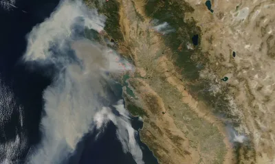
As one of the worst wildfires in California history continues to extend the state’s worst wildfire season, Faith Kerns at The Conversation notes that which houses burn and which don’t is more predictable that it may seem.
While “[i]t is commonly thought that it takes direct flame to spread a fire,” she writes, it’s often embers that are to blame.
“These small bits of burning debris can be lofted long distances by the wind. They can then end up igniting landscaping materials like combustible mulch, or enter homes through vulnerable spots – gutters teeming with debris, unscreened attic vents, open or broken windows, old roofs with missing shingles.”
The damage to homes is also deeply affected by whether or not those areas are thought to be at risk, and whether or not building codes reflect that. Measures to decrease the damage to homes caused by wildfires can include regulations on building materials and building codes.
"Researchers recommend what is known as a “coupled approach” to home and building survival. This means the development and maintenance of an effective defensible space, as well as the careful selection of construction materials and correct installation to ensure that, for example, there are not gaps in siding or roofing that would allow embers to penetrate."
But in a state where there’s usually a building boom somewhere, the most effective method of prevention is also the most painful.
“Decision-makers also need,” Kerns writes, “to be willing to take on the most taboo topic of them all: recognizing that there are places houses simply shouldn’t be built, or rebuilt, at all.”
Seasonal wildfires have always part of the ecology of much of California, but they are becoming more frequent and more intense, in part due urban sprawl (the Wildland-Urban Interface) and in part due to climate change.
“It’s not something that we should, or ever could, hope to fully contain,” Kerns writes. “Our only chance is learning, really and truly and finally learning, to live with it.
FULL STORY: California fire damage to homes is less ‘random’ than it seem

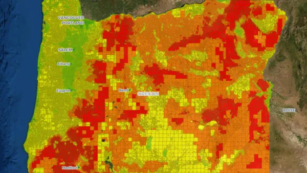
Oregon Issues Wildfire Risk Map
After homeowners received letters assessing their property’s fire risk, questions remain about the next steps in building fire resilience.
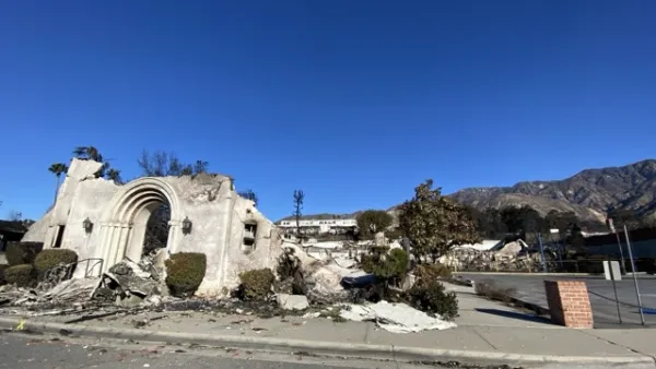
UCLA Experts Offer Critical Support for LA Wildfire Response and Recovery
The UCLA Luskin Center for Innovation offers expert guidance on LA wildfire response and recovery, addressing critical issues like water safety, air quality, equitable rebuilding, and climate adaptation to promote resilience and sustainability.
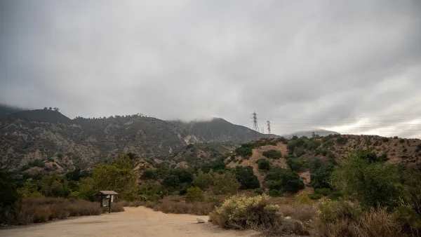
Wildfires Devastate LA Outdoor Education Spaces and Schools
The current Los Angeles wildfires have destroyed schools and outdoor education spaces like Eaton Canyon, displacing families and disrupting vital learning and community resources while highlighting the region’s vulnerability to natural disasters.

National Parks Layoffs Will Cause Communities to Lose Billions
Thousands of essential park workers were laid off this week, just before the busy spring break season.

Retro-silient?: America’s First “Eco-burb,” The Woodlands Turns 50
A master-planned community north of Houston offers lessons on green infrastructure and resilient design, but falls short of its founder’s lofty affordability and walkability goals.

Delivering for America Plan Will Downgrade Mail Service in at Least 49.5 Percent of Zip Codes
Republican and Democrat lawmakers criticize the plan for its disproportionate negative impact on rural communities.

Test News Post 1
This is a summary

Test News Headline 46
Test for the image on the front page.

Balancing Bombs and Butterflies: How the National Guard Protects a Rare Species
The National Guard at Fort Indiantown Gap uses GIS technology and land management strategies to balance military training with conservation efforts, ensuring the survival of the rare eastern regal fritillary butterfly.
Urban Design for Planners 1: Software Tools
This six-course series explores essential urban design concepts using open source software and equips planners with the tools they need to participate fully in the urban design process.
Planning for Universal Design
Learn the tools for implementing Universal Design in planning regulations.
EMC Planning Group, Inc.
Planetizen
Planetizen
Mpact (formerly Rail~Volution)
Great Falls Development Authority, Inc.
HUDs Office of Policy Development and Research
NYU Wagner Graduate School of Public Service