


The Boston Planning & Development Agency released a powerful new map of the entire city—complete with layers like shadows, flood plains, and zoning districts—to the public.
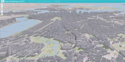
Tim Logan reports on a new digital 3D map produced by the Boston Planning & Development Agency (BDPA) that models the entire city.
The map is "the latest step in the BPDA’s push to be more transparent, and to spark conversations about planning for the city’s future," according to Logan. Previously, BDPA housed a wooden scale model on the ninth floor of City Hall. The new digital map is public, and the hope is that it will inspire the public to engage with the city's development in new ways.
The map maps 129,000 buildings from East Boston to Mottapan, explains Logan. "The map is pannable and scannable, and detailed enough to capture backyard sheds, rooftop furniture, and lots of trees. And it comes with tools that allow anyone to layer on zoning maps, schools, MBTA stops, and even flood-prone areas."
FULL STORY: You can see your home from here. A new 3D map covers the entire city


Boston to Launch New Downtown Plan
The Boston Planning & Development Agency will hire consultants to craft a vision for its rapidly changing downtown.

Boston Gets a New Planning Department
After 67 years since its formation, the Boston Planning and Development Agency is no more.

Boston to Begin Zoning Code Update, Mayor Announces
It’s been nearly 60 years, but the city of Boston is finally ready to do a comprehensive rewrite of its zoning code.

Analysis: Cybertruck Fatality Rate Far Exceeds That of Ford Pinto
The Tesla Cybertruck was recalled seven times last year.

National Parks Layoffs Will Cause Communities to Lose Billions
Thousands of essential park workers were laid off this week, just before the busy spring break season.

Retro-silient?: America’s First “Eco-burb,” The Woodlands Turns 50
A master-planned community north of Houston offers lessons on green infrastructure and resilient design, but falls short of its founder’s lofty affordability and walkability goals.

Test News Post 1
This is a summary

Analysis: Cybertruck Fatality Rate Far Exceeds That of Ford Pinto
The Tesla Cybertruck was recalled seven times last year.

Test News Headline 46
Test for the image on the front page.
Urban Design for Planners 1: Software Tools
This six-course series explores essential urban design concepts using open source software and equips planners with the tools they need to participate fully in the urban design process.
Planning for Universal Design
Learn the tools for implementing Universal Design in planning regulations.
EMC Planning Group, Inc.
Planetizen
Planetizen
Mpact (formerly Rail~Volution)
Great Falls Development Authority, Inc.
HUDs Office of Policy Development and Research
NYU Wagner Graduate School of Public Service