


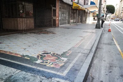
An app called Surveyor is making it easier to collect better data on curbs.
Kyle Wiggers reports on the startup Coord, which developed an app called Surveyor to locate curbs and catalog information about them. Existing data leaves a lot to be desired, says Wiggers:
The trouble is, the data’s often incomplete, and in some cases erroneous. Trees and other obstructions obscure street signs. Miscalibrated vehicle headings make it tough (and sometimes impossible) to suss out locations. And curb cuts, loading zones, meter prices, and curb paint aren’t consistently visible from street level.
The app allows users to mark the start and end of a curb space and note any features. Surveyor then adds the location to a 3-D map. So far, Coord has gathered data on 12,000 curbs in San Francisco and Los Angeles, along with earlier data it collected from 200,000 curbs in various cities and 86 percent of tollways in the United States, reports Wiggers.
Coord’s broader goal is to provide data to public agencies and companies on different modes and street elements, says Wiggers:
Toll agencies can tap Coord’s APIs [application programming interface] to calculate toll prices and communicate them through an app, for example, and bike-sharing companies could leverage its location datasets to pinpoint stations on a map. And cities can use it to better allocate parking zones and manage the flow of traffic.
Surveyor is currently a subscription service that helps participating organizations and agencies develop local databases.
FULL STORY: Coord’s Surveyor app uses AR to map curbs and sidewalks

Next on the List for Data Startups: Managing Curb Space
The humble curb is getting crowded: not only with new modes of transportation, but also with a slew of new data tools aiming to keep track of it all.

Mapping the Law of the Land: Curbside Access
More uses and modes than ever are fighting for curb space in growing cities. Here's an app to make sense of what you can do, and when, along this valued real estate.
State of Curbs & Parking Report Reveals Glut of Data
As the uses of curb space become more diverse, city officials are working to understand how to best manage this increasingly important urban amenity.

Analysis: Cybertruck Fatality Rate Far Exceeds That of Ford Pinto
The Tesla Cybertruck was recalled seven times last year.

National Parks Layoffs Will Cause Communities to Lose Billions
Thousands of essential park workers were laid off this week, just before the busy spring break season.

Retro-silient?: America’s First “Eco-burb,” The Woodlands Turns 50
A master-planned community north of Houston offers lessons on green infrastructure and resilient design, but falls short of its founder’s lofty affordability and walkability goals.

Test News Post 1
This is a summary

Analysis: Cybertruck Fatality Rate Far Exceeds That of Ford Pinto
The Tesla Cybertruck was recalled seven times last year.

Test News Headline 46
Test for the image on the front page.
Urban Design for Planners 1: Software Tools
This six-course series explores essential urban design concepts using open source software and equips planners with the tools they need to participate fully in the urban design process.
Planning for Universal Design
Learn the tools for implementing Universal Design in planning regulations.
EMC Planning Group, Inc.
Planetizen
Planetizen
Mpact (formerly Rail~Volution)
Great Falls Development Authority, Inc.
HUDs Office of Policy Development and Research
NYU Wagner Graduate School of Public Service