


In a distant and expensive future, there are two new ways to get across the San Francisco Bay without a car. One will have a much better view.

"Long the holy grail for cycling advocates in the Bay Area — a bike and pedestrian path spanning the entire length of the Bay Bridge, offering unparalleled views of San Francisco and a carbon-free alternative to soul-sucking traffic — has, for decades, remained tantalizingly out of reach," writes Erin Baldassari.
That holy grail is one step closer to becoming a reality, however, after the Metropolitan Transportation Commission, a regional planning agency spanning nine Bay Area counties, revealed a new study of the Bay Bridge West Span Bike Path last week.
The recent report narrows down six design alternatives created and presented to the public in 2016 to a preferred design alternative. According to the Metropolitan Transportation Commission website set up to promote the project, "[the preferred design alternative] features an alignment running along the north side of the West Span with a touchdown in San Francisco at Essex Street (parallel to First and Second streets, between Folsom to the north and Harrison to the south). The recommendation for the Yerba Buena Island connection joins the East Span path via Southgate Road along the east side of Hillcrest Road. The path would share architectural features will the East Span path, providing continuity of experience along the entire crossing."
According to Bladessari, the new report is the closest regional planners have come to "understanding the full magnitude of construction and its associated costs" (which, by the way, are estimated at $341 million to nearly $429 million).
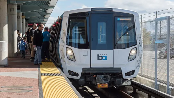
But wait, there's more non-automotive transportation planning news from the Bay Area: BART has also announced a new planning process for a second transbay tube
Adam Bronklow reports: "The possibility of a second tube—BART’s official announcement suggests that 'tube' may not be the correct term for whatever the agency ends up building, instead stressing the term 'second crossing'—has floated around the Bay Area for decades, but this is the first time BART appears to be planning concrete measures for it."
The BART website set up to promote the planning process includes a list of opportunities and objectives for the project. Among the objectives, the ability to double BART bay crossing capacity.
Brinklow's coverage provides context of the growing popular and political support for the crossing.
FULL STORY: Bay Bridge bike path on west span would offer ‘breathtaking views’ — and a huge price tag

Recommendations for Improving the Bay Area's Busiest Commute
One of the nation's busiest commute corridors will get a lot busier in coming decades with no large infrastructure investment in sight. SPUR has some ideas about how the East Bay to San Francisco corridor can be improved right now.
$100 Billion Bay Area Transportation Tax Considered for November 2020 Ballot
Two years after voters in the nine-county Bay Area agreed to hike tolls on the region's seven state-owned bridges, regional business leaders are hoping they will approve a one-cent regional sales tax to fund $100 billion in transportation projects.
The Many Ongoing Public Transportation Projects of the Bay Area
The San Francisco Chronicle offers a round-up of 11 big transit projects, by Caltrans, BART, SFMTA, and others, making progress around the bay.

Analysis: Cybertruck Fatality Rate Far Exceeds That of Ford Pinto
The Tesla Cybertruck was recalled seven times last year.

National Parks Layoffs Will Cause Communities to Lose Billions
Thousands of essential park workers were laid off this week, just before the busy spring break season.

Retro-silient?: America’s First “Eco-burb,” The Woodlands Turns 50
A master-planned community north of Houston offers lessons on green infrastructure and resilient design, but falls short of its founder’s lofty affordability and walkability goals.

Test News Post 1
This is a summary

Analysis: Cybertruck Fatality Rate Far Exceeds That of Ford Pinto
The Tesla Cybertruck was recalled seven times last year.

Test News Headline 46
Test for the image on the front page.
Urban Design for Planners 1: Software Tools
This six-course series explores essential urban design concepts using open source software and equips planners with the tools they need to participate fully in the urban design process.
Planning for Universal Design
Learn the tools for implementing Universal Design in planning regulations.
EMC Planning Group, Inc.
Planetizen
Planetizen
Mpact (formerly Rail~Volution)
Great Falls Development Authority, Inc.
HUDs Office of Policy Development and Research
NYU Wagner Graduate School of Public Service