


Los Angeles transit planners wants to connect two of its rail lines with a bus rapid transit line. The idea has critics.
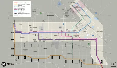
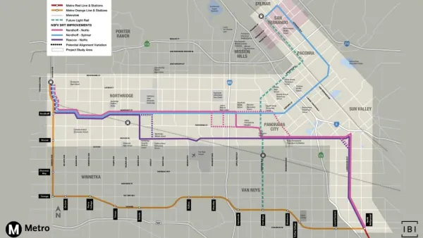
The Los Angeles County Transportation Authority (Metro) is considering a bus rapid transit lane to run through the San Fernando Valley, but the project has encountered public resistance before even beginning environmental review. A recently formed group called "Save the San Fernando Valley" complained that the public had not had ample time to understand and comment on the project.
The exact route of the bus lane from which the group is hoping to save The Valley has yet to be determined. Some argue the bus would be less disruptive if it ran on Roscoe Boulevard rather than Nordhoff Street. However, "Running the entire project along Roscoe, however, would mean bypassing California State University, Northridge. School officials have pushed hard for better transit options for students, and Metro staff estimates that ridership on the bus would be highest between the university and the forthcoming light rail line to the east,” Elijah Chiland reports for Curbed. Still, the group thinks the disruption to parking and traffic on Nordhoff makes the bus line an unworkable project.
Supporters of the project point out, “The bus line would provide key connections to a planned light rail line along Van Nuys Boulevard and the Orange Line, an existing rapid bus that travels in dedicated lanes to the south of the proposed North Valley route,” Chiland writes. Metro hopes the project will be complete in time for the Olympics.
Bus rapid transit proposals have had trouble with local neighborhood groups in Los Angeles in recent weeks. Another proposal for a route connecting The Valley to the nearby city of Pasadena also encountered strident local opposition earlier this month.
FULL STORY: ‘Stop this madness’: Valley residents trying to block bus rapid transit

New Bus Rapid Transit Line Proposed for L.A.'s San Fernando Valley
Measure M, approved by L.A. County voters in 2016, is enabling a slew of transit projects in the San Fernando Valley.

Controversial BRT Plans Revised in Los Angeles
The proposed changes to plans for a bus rapid transit route on Colorado Boulevard are an attempt to compromise between competing community concerns.
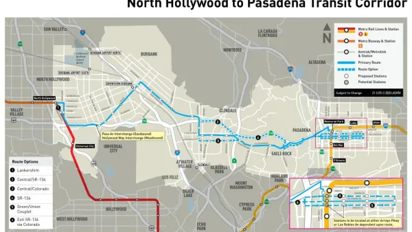
Details of the North Hollywood-Pasadena Bus Rapid Transit Line
Still under environmental review, plans are still being made for the bus rapid transit line that would connect North Hollywood and Pasadena.

National Parks Layoffs Will Cause Communities to Lose Billions
Thousands of essential park workers were laid off this week, just before the busy spring break season.

Retro-silient?: America’s First “Eco-burb,” The Woodlands Turns 50
A master-planned community north of Houston offers lessons on green infrastructure and resilient design, but falls short of its founder’s lofty affordability and walkability goals.

Delivering for America Plan Will Downgrade Mail Service in at Least 49.5 Percent of Zip Codes
Republican and Democrat lawmakers criticize the plan for its disproportionate negative impact on rural communities.

Test News Post 1
This is a summary

Test News Headline 46
Test for the image on the front page.

Balancing Bombs and Butterflies: How the National Guard Protects a Rare Species
The National Guard at Fort Indiantown Gap uses GIS technology and land management strategies to balance military training with conservation efforts, ensuring the survival of the rare eastern regal fritillary butterfly.
Urban Design for Planners 1: Software Tools
This six-course series explores essential urban design concepts using open source software and equips planners with the tools they need to participate fully in the urban design process.
Planning for Universal Design
Learn the tools for implementing Universal Design in planning regulations.
EMC Planning Group, Inc.
Planetizen
Planetizen
Mpact (formerly Rail~Volution)
Great Falls Development Authority, Inc.
HUDs Office of Policy Development and Research
NYU Wagner Graduate School of Public Service