


The massive Port Lands infrastructure project will transform an industrial area by carving out a new island.
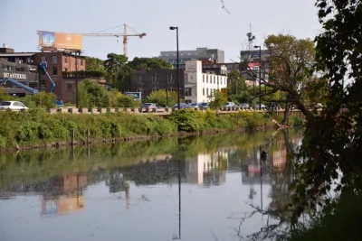
Kenyon Wallace takes a closer look at the Port Lands Flood Protection Project, a $1.25 billion project to naturalize the Don River pathway and help with flood control through construction of a river valley that will result in an island at the river’s mouth.
"The Port Lands, located south of Lake Shore Boulevard between Leslie Street in the east and Cherry Street in the west, are a primarily industrial and commercial neighbourhood built on landfill that was once home to oil tank farms, factories and a city incinerator," writes Wallace.
He describes the different phases of the project in more detail, including the excavation of the river valley, treatment of groundwater, and landscaping along the edge of the river. The entire area will also be raised and will undergo soil stabilization.
"The new island, named Villiers Island, will feature parklands, walking and biking trails, and residential and commercial real estate (not to mention great views of the city skyline). It will also feature the only natural shoreline within the inner harbour, allowing for easy entry into Lake Ontario with canoes and kayaks," says Wallace.
FULL STORY: How do you build an island in Toronto?


Expanding the Concept of Transit-Oriented Development: Lessons from Abroad
Keeping transit planning and development siloed can limit opportunities to build affordable housing and vibrant neighborhoods.

3D Modeling Aids in Predicting Hurricane Damage
Texas researchers are testing the tool in Galveston, where Hurricane Ike caused billions in damage in 2008.
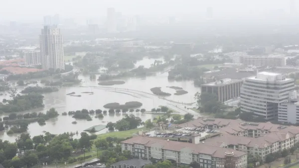
Texas Flood Plan Shows One in Six Residents Live With Flood Risk
One-fourth of the state’s land falls within 100-year or 500-year floodplains.

National Parks Layoffs Will Cause Communities to Lose Billions
Thousands of essential park workers were laid off this week, just before the busy spring break season.

Retro-silient?: America’s First “Eco-burb,” The Woodlands Turns 50
A master-planned community north of Houston offers lessons on green infrastructure and resilient design, but falls short of its founder’s lofty affordability and walkability goals.

Delivering for America Plan Will Downgrade Mail Service in at Least 49.5 Percent of Zip Codes
Republican and Democrat lawmakers criticize the plan for its disproportionate negative impact on rural communities.

Test News Post 1
This is a summary

Test News Headline 46
Test for the image on the front page.

Balancing Bombs and Butterflies: How the National Guard Protects a Rare Species
The National Guard at Fort Indiantown Gap uses GIS technology and land management strategies to balance military training with conservation efforts, ensuring the survival of the rare eastern regal fritillary butterfly.
Urban Design for Planners 1: Software Tools
This six-course series explores essential urban design concepts using open source software and equips planners with the tools they need to participate fully in the urban design process.
Planning for Universal Design
Learn the tools for implementing Universal Design in planning regulations.
EMC Planning Group, Inc.
Planetizen
Planetizen
Mpact (formerly Rail~Volution)
Great Falls Development Authority, Inc.
HUDs Office of Policy Development and Research
NYU Wagner Graduate School of Public Service