


A new study drives home the need for heat reduction measures in areas populated by lower-income residents.
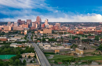
A heat map produced by measuring temperatures across Cincinnati on August 10, 2020 bears a striking resemblance to maps of household income, neighborhood demographics, and the history of redlining, reports Danny Wicentowski. The findings of the study support the unfortunate reality that communities of color in the United States bear the brunt of climate change impacts.
The report, made possible by funding from the National Oceanic and Atmospheric Administration's Climate Program Office, "observed that large developments absorb and retain heat throughout the day, affecting even nearby residences," Wicentowski writes. The report further noted a commonality between the hottest areas: a notable lack of vegetation. Conversely, the coolest temperatures measured on that summer day were recorded in areas with ample tree-cover.
Wicentowski reminds readers that minimal tree canopy in lower-income areas is hardly a revelation and has even been noted in a 2018 version of the Green Cincinnati Plan. One of the plan's "major resiliency recommendations: increase the city’s tree canopy to shield communities from ever-increasing heat in the summer and to soak up water from those massive rainfall events."
According to a Cincinnati Parks press release, the data from the study will be used to prioritize areas of service to "implement targeted planting plans in communities with the greatest need."

Research Shows Urban Trees Stave off Depression
A new study shows that regular exposure to trees and green spaces has a powerful impact on depression and mental health.
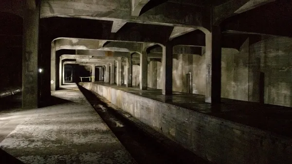
Cincinnati Seeks to Repurpose Its Unused Subway Tunnel
City officials are looking for proposals to use Cincinnati's long-abandoned subway tunnels, but not for transit; they already tried that.

Planting for the Future: The Urban Trees of Tomorrow
How urban forest managers are preparing urban tree canopies for tomorrow’s climates.

Analysis: Cybertruck Fatality Rate Far Exceeds That of Ford Pinto
The Tesla Cybertruck was recalled seven times last year.

National Parks Layoffs Will Cause Communities to Lose Billions
Thousands of essential park workers were laid off this week, just before the busy spring break season.

Retro-silient?: America’s First “Eco-burb,” The Woodlands Turns 50
A master-planned community north of Houston offers lessons on green infrastructure and resilient design, but falls short of its founder’s lofty affordability and walkability goals.

Test News Post 1
This is a summary

Analysis: Cybertruck Fatality Rate Far Exceeds That of Ford Pinto
The Tesla Cybertruck was recalled seven times last year.

Test News Headline 46
Test for the image on the front page.
Urban Design for Planners 1: Software Tools
This six-course series explores essential urban design concepts using open source software and equips planners with the tools they need to participate fully in the urban design process.
Planning for Universal Design
Learn the tools for implementing Universal Design in planning regulations.
EMC Planning Group, Inc.
Planetizen
Planetizen
Mpact (formerly Rail~Volution)
Great Falls Development Authority, Inc.
HUDs Office of Policy Development and Research
NYU Wagner Graduate School of Public Service