


With urban pollution and traffic violence disproportionately affecting communities of color, better management of public space and streets could improve equity in cities.
Sahar Shirazi assesses the changes to streets and public space brought on by the pandemic, noting that "fallout often hits hardest on those historically marginalized and those most vulnerable." As we make dramatic changes in how we use public space, Shirazi argues that "[i]t is essential, now more than ever, that any urban equation factor in the reality that our urban environments have historically been unequal places."
The choices made by policymakers now "can either exacerbate those inequities, or mitigate them." Shirazi points to the intensifying battle over curb space as one area where "cities can use their existing authority over curbs to shift driver behavior, more effectively allocate curb space to match the needs of the community, and improve safety, environmental sustainability, and revenue generation," partnering policy with technology to "intelligently and democratically mitigate the negative impacts of these changes and improve life for all city-dwellers, especially those already facing financial hardship or discrimination."
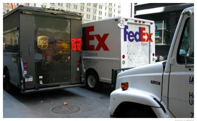
Shirazi recommends that cities charge companies like Amazon and UPS for parking and curbside access. "Additionally, more efficient parking enforcement can improve traffic flow and reduce transit time, which will also be a boon to lower-income communities which rely more heavily on public transit and frequently have higher greenhouse gas emissions in their neighborhoods and worse air quality than other city dwellers."
Shirazi also emphasizes the importance of achieving two important goals: zero traffic fatalities and zero carbon emissions, both of which disproportionately harm communities of color. "By addressing road safety, parking, emissions, and how we allocate and charge for curb usage, cities can make strides to address inequities present today."
FULL STORY: Op-Ed: Managing Our Streets Better Can Reduce Inequities In Our Cities

Connecticut Launches Complete Streets Standards
The new policy calls for sidewalks, bike lanes, and crosswalks on state roads and state-funded road projects.
Atlanta Urges Tactical Urbanism To Speed Up Vision Zero Goals
The city's department of transportation has released a guide to help community groups implement low-cost 'tactical urbanism' projects.

Study: Poor Air Quality Fuels COVID Transmission
Communities exposed to higher levels of air pollution experience higher rates of infection, particularly in areas with high population density.

National Parks Layoffs Will Cause Communities to Lose Billions
Thousands of essential park workers were laid off this week, just before the busy spring break season.

Retro-silient?: America’s First “Eco-burb,” The Woodlands Turns 50
A master-planned community north of Houston offers lessons on green infrastructure and resilient design, but falls short of its founder’s lofty affordability and walkability goals.

Delivering for America Plan Will Downgrade Mail Service in at Least 49.5 Percent of Zip Codes
Republican and Democrat lawmakers criticize the plan for its disproportionate negative impact on rural communities.

Test News Post 1
This is a summary

Test News Headline 46
Test for the image on the front page.

Balancing Bombs and Butterflies: How the National Guard Protects a Rare Species
The National Guard at Fort Indiantown Gap uses GIS technology and land management strategies to balance military training with conservation efforts, ensuring the survival of the rare eastern regal fritillary butterfly.
Urban Design for Planners 1: Software Tools
This six-course series explores essential urban design concepts using open source software and equips planners with the tools they need to participate fully in the urban design process.
Planning for Universal Design
Learn the tools for implementing Universal Design in planning regulations.
EMC Planning Group, Inc.
Planetizen
Planetizen
Mpact (formerly Rail~Volution)
Great Falls Development Authority, Inc.
HUDs Office of Policy Development and Research
NYU Wagner Graduate School of Public Service