


A 1971 effort to quantify the city's values and design goals reflects many of the same priorities that planners and residents face today.
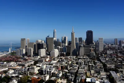
In 1971, San Francisco published its Urban Design Plan, a blueprint for preserving the character of the city and addressing growing concerns about building height and density. John King describes the plan, which warned against "unstructured and unabated growth" and the "jarring disharmony" caused by 'unusual' buildings like the Transamerica Pyramid, approved for construction in 1969.
The plan also acknowledged the role of high-rises in the growing city, "a necessary and expressive form for much of the city’s office, apartment, hotel and institutional development," and encourages 'respectful' new development that fits into the city's unique environment.
The plan includes a wealth of photos, sketches, and maps that illustrate the planners' ideas about creating a pleasant urban environment and their design best-practices.
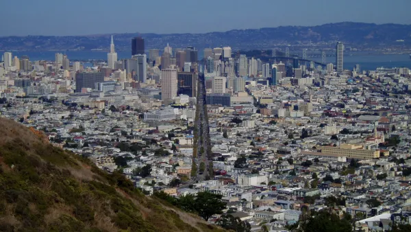
Notably, the plan calls for reducing traffic in residential areas through what we now call traffic calming measures such as narrowed streets, landscaping, and traffic diversion. Planners in 1971 also suggested "close by and visible" parks, pointing to the city's waterfront as an underused recreational space. As King notes, "This was written 20 years before the Embarcadero Freeway was torn down, and 30 years before Crissy Field opened in the Presidio."
The conclusion we can draw from the plan more broadly, writes King, is the idea that the city's fractious population can come to some agreement on what they value in their built environment—and that San Franciscans love their city enough to fight for it.
FULL STORY: Planners tried to define what makes San Francisco special — in 1971. Here’s how their designs fared

San Francisco Could Strike Deal on New Tower
The city is leveraging height increases and density bonuses to acquire more properties for affordable housing.

How the Built Environment Impacts Public Health
New research sheds light on how the brain responds to urban environments and architecture.
Is it Time to Revive the Pattern Language?
Software and other fields have made brilliant progress with the pattern language methodology, while built environment fields lag badly, mired in parochial debates over the massive book that invented the methodology.

National Parks Layoffs Will Cause Communities to Lose Billions
Thousands of essential park workers were laid off this week, just before the busy spring break season.

Retro-silient?: America’s First “Eco-burb,” The Woodlands Turns 50
A master-planned community north of Houston offers lessons on green infrastructure and resilient design, but falls short of its founder’s lofty affordability and walkability goals.

Delivering for America Plan Will Downgrade Mail Service in at Least 49.5 Percent of Zip Codes
Republican and Democrat lawmakers criticize the plan for its disproportionate negative impact on rural communities.

Test News Post 1
This is a summary

Test News Headline 46
Test for the image on the front page.

Balancing Bombs and Butterflies: How the National Guard Protects a Rare Species
The National Guard at Fort Indiantown Gap uses GIS technology and land management strategies to balance military training with conservation efforts, ensuring the survival of the rare eastern regal fritillary butterfly.
Urban Design for Planners 1: Software Tools
This six-course series explores essential urban design concepts using open source software and equips planners with the tools they need to participate fully in the urban design process.
Planning for Universal Design
Learn the tools for implementing Universal Design in planning regulations.
EMC Planning Group, Inc.
Planetizen
Planetizen
Mpact (formerly Rail~Volution)
Great Falls Development Authority, Inc.
HUDs Office of Policy Development and Research
NYU Wagner Graduate School of Public Service