


A new study shows a disparity between the frequency of crosswalks in San Francisco's northern and southern neighborhoods.
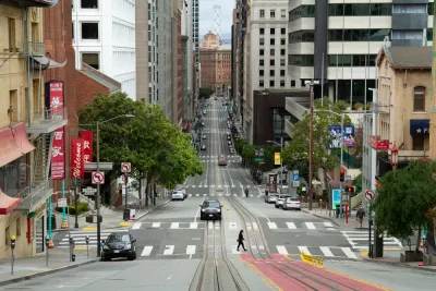
Heather Knight reports on a new study from Marcel Maron, who analyzed all of San Francisco's 6,399 intersections and mapped the existence or lack of crosswalks at each one. Maron's results showed a stark disparity between neighborhoods. "Crosswalk hot spots with clusters of intersections sporting the painted passages are almost entirely located in the northern half of the city, particularly in richer neighborhoods including Pacific Heights, Presidio Heights, Laurel Heights, Alamo Square, Nob Hill, the Financial District and South Beach." Meanwhile, "Crosswalk cold spots, where pedestrians can walk blocks without encountering a crosswalk, are almost entirely in the southern half of the city."
Overall, 58% of San Francisco’s intersections have crosswalks, but their distribution varies widely. In Pacific Heights, 83% of intersections have them, while in Bayview-Hunters Point, 51% do. In the Mission, which has far more traffic and pedestrians than Pacific Heights, 63% of intersections have crosswalks.
Another study Moran conducted in 2020 analyzed the city's nearly 3,000 bus stops and found a similar disparity in amenities like seating, shelters, and signage between the northern and southern halves of the city. "Also, routes with the longest intervals between buses were the least likely to have seats and shelters — making passengers who have to wait the longest do so in the least comfortable way. This, again, despite San Francisco’s claim to be a transit-first city," notes Knight.
Moran argues that these disparities create a vicious cycle, discouraging people from walking or using transit due to safety and comfort concerns. "And then the city can say better bus stops and crosswalks aren’t necessary because people aren’t using those spaces."
FULL STORY: He mapped every crosswalk in S.F. The results show a startling safety gap for some neighborhoods

Connecticut Launches Complete Streets Standards
The new policy calls for sidewalks, bike lanes, and crosswalks on state roads and state-funded road projects.
NACTO Releases Updated Urban Bikeway Guide
The third edition of the nationally recognized road design guide includes detailed design advice for roads that prioritize safety and accessibility for all users.
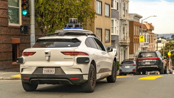
Waymo Robotaxis Often Fail to Stop for Pedestrians
One journalist recorded more than a dozen instances of Waymo autonomous cars speeding by when he tried to cross the street.

Analysis: Cybertruck Fatality Rate Far Exceeds That of Ford Pinto
The Tesla Cybertruck was recalled seven times last year.

National Parks Layoffs Will Cause Communities to Lose Billions
Thousands of essential park workers were laid off this week, just before the busy spring break season.

Retro-silient?: America’s First “Eco-burb,” The Woodlands Turns 50
A master-planned community north of Houston offers lessons on green infrastructure and resilient design, but falls short of its founder’s lofty affordability and walkability goals.

Test News Post 1
This is a summary

Analysis: Cybertruck Fatality Rate Far Exceeds That of Ford Pinto
The Tesla Cybertruck was recalled seven times last year.

Test News Headline 46
Test for the image on the front page.
Urban Design for Planners 1: Software Tools
This six-course series explores essential urban design concepts using open source software and equips planners with the tools they need to participate fully in the urban design process.
Planning for Universal Design
Learn the tools for implementing Universal Design in planning regulations.
EMC Planning Group, Inc.
Planetizen
Planetizen
Mpact (formerly Rail~Volution)
Great Falls Development Authority, Inc.
HUDs Office of Policy Development and Research
NYU Wagner Graduate School of Public Service