


The Durham-Chapel Hill-Carrboro Metropolitan Planning Organization accomplished a major shift in transportation planning priorities.
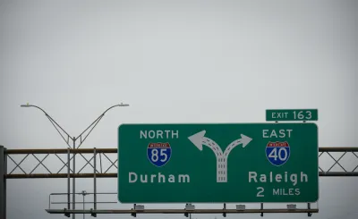
The Durham-Chapel Hill-Carrboro Metropolitan Planning Organization (MPO) in February approved a 30-year regional transportation plan that eliminates previously planned road widening projects.
Richard Stradling reports for the News & Observer on the shift in transportation planning in the Research Triangle region. Specifically, according to Stradling, the 2050 Metropolitan Transportation Plan eliminates proposals to widen the Durham Freeway near Research Triangle Park and to convert sections of U.S. 70 and U.S. 15-501 into expressways.
In the place of those automobile infrastructure projects, "the plan calls for spending more on transit, including increased bus service and new bus rapid transit lines," reports Stradling. "It also places more emphasis on bike lanes, crosswalks and sidewalks used by cyclists and pedestrians."
"The plan is meant to support goals pushed by the public and adopted by the MPO’s board that include eliminating fatal crashes, reducing carbon emissions to zero and ensuring that everyone has access to affordable transportation," explains Stradling.
The newly approved plan goes further by promising to end all new "major roadway projects" by 2040. Until then, the MPO is still planning on a few highway investments, namely the widening of Interstates 40 and 85 in Orange County from four to six lanes [paywall].
FULL STORY: Durham, Orange chart new transportation path away from more and bigger highways

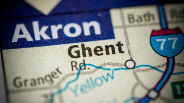
Local Opposition to Ohio DOT's I-77 Widening Plans Near Akron
The Ohio Department of Transportation wants to add lanes to Interstate 77 outside Akron to reduce congestion. Some local officials think the project will connect the region to the East Coast; others think the money would be better spent locally.
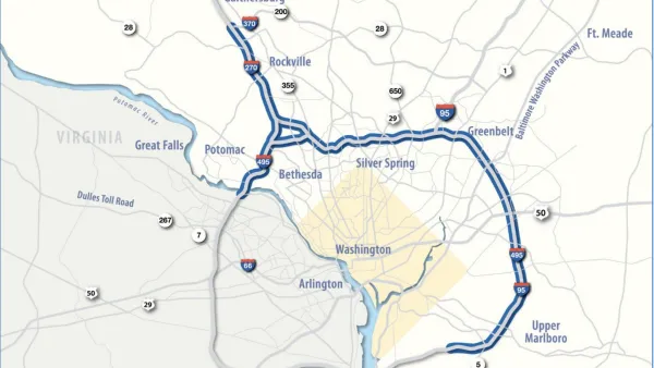
Maryland Highway Widening Plans Moving Forward Under New Governor
Maryland Governor Wes Moore is differentiating his new administration from his predecessor’s, but some projects, like the widening of federal highways in the Capital Beltway, stay the same.

Tolling Gaining Traction for Highway Projects in Kansas
After the state broke ground on a tolled express lane project at the eastern edge of Kansas, near Kansas City, tolls are also under consideration in the nascent stages of a corridor study located at the southwest edge of the same region.

National Parks Layoffs Will Cause Communities to Lose Billions
Thousands of essential park workers were laid off this week, just before the busy spring break season.

Retro-silient?: America’s First “Eco-burb,” The Woodlands Turns 50
A master-planned community north of Houston offers lessons on green infrastructure and resilient design, but falls short of its founder’s lofty affordability and walkability goals.

Delivering for America Plan Will Downgrade Mail Service in at Least 49.5 Percent of Zip Codes
Republican and Democrat lawmakers criticize the plan for its disproportionate negative impact on rural communities.

Test News Post 1
This is a summary

Test News Headline 46
Test for the image on the front page.

Balancing Bombs and Butterflies: How the National Guard Protects a Rare Species
The National Guard at Fort Indiantown Gap uses GIS technology and land management strategies to balance military training with conservation efforts, ensuring the survival of the rare eastern regal fritillary butterfly.
Urban Design for Planners 1: Software Tools
This six-course series explores essential urban design concepts using open source software and equips planners with the tools they need to participate fully in the urban design process.
Planning for Universal Design
Learn the tools for implementing Universal Design in planning regulations.
EMC Planning Group, Inc.
Planetizen
Planetizen
Mpact (formerly Rail~Volution)
Great Falls Development Authority, Inc.
HUDs Office of Policy Development and Research
NYU Wagner Graduate School of Public Service