


An analysis of asphalt art around the country indicates that painted intersections and roads can dramatically improve pedestrian safety.
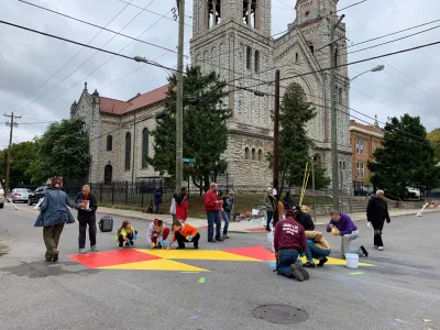
According to a new study reported on by Kea Wilson, “Installing asphalt art on roads and intersection can cut crashes between motorists and other road users by a staggering 50%,” showing that this relatively inexpensive intervention can save a significant number of lives. “In a new report from Bloomberg Philanthropies, researchers analyzed crash rates and driver behavior before and after traffic-calming art projects were added to the 17 US roads and intersections for which the best possible data and imagery was available.”
Not only did the projects slash crashes involving vulnerable road users in half, they also lessened injury-causing crashes by an average of 37%, and cut overall crashes by 17%, too. Drivers even yielded to pedestrians in colorful crosswalks 27% more often, even though many intersections featured high-visibility paint before.
Unfortunately, many policymakers haven’t recognized the utility of asphalt art. “The most recent proposed edition of the Manual of Uniform Traffic Control Devices — the document which sets the standard for most of the signs, signals and street markings that annotate the right of way— warned against colorful crosswalks, in part, advocates say, because existing AV technology struggles to recognize them as places where people walk.” Other concerns include whether pedestrians with vision impairments can safely navigate colorful art, and how cities can maintain street murals.
Janette Sadik-Khan, former New York City transportation commissioner and principal at Bloomberg, “stresses that researchers are just beginning to understand the power of public art to transform public safety — and that the cost of trying it is shockingly low.” According to Sadik-Khan, “Bloomberg’s initiative provides a blueprint that cities around the world can follow, and hopes the safety study will fuel more such art.”
FULL STORY: How asphalt art can protect vulnerable road users


Austin Completes First Round of Vision Zero Projects
Small, localized interventions such as changes to signal timing and crosswalk improvements are saving lives and improving traffic safety.
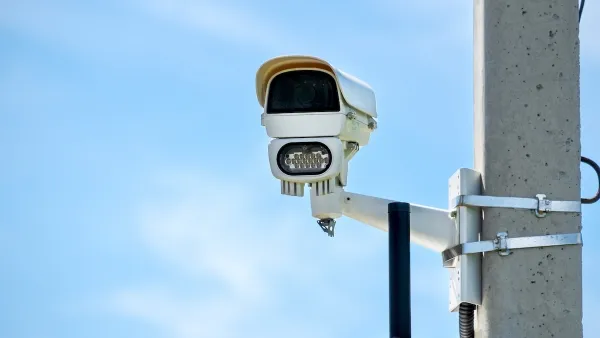
Philly Speed Camera Program Cuts Fatalities in Half
Excessive speeding along dangerous segments of Roosevelt Boulevard dropped by 90 percent after the city installed automated enforcement cameras.
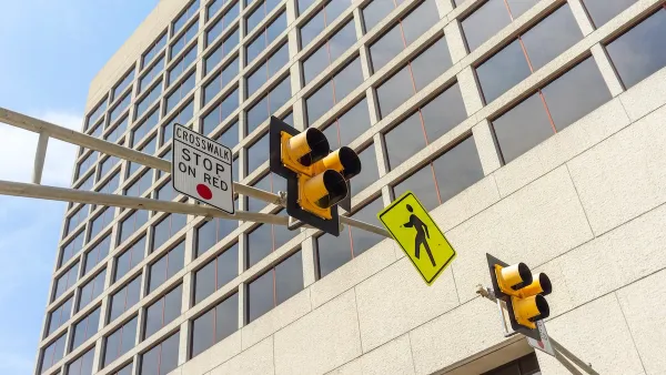
Austin Adds Pedestrian Improvements at Hundreds of Intersections
The city added leading pedestrian interval technology to over 600 intersections, giving pedestrians time to cross before vehicles.

National Parks Layoffs Will Cause Communities to Lose Billions
Thousands of essential park workers were laid off this week, just before the busy spring break season.

Retro-silient?: America’s First “Eco-burb,” The Woodlands Turns 50
A master-planned community north of Houston offers lessons on green infrastructure and resilient design, but falls short of its founder’s lofty affordability and walkability goals.

Delivering for America Plan Will Downgrade Mail Service in at Least 49.5 Percent of Zip Codes
Republican and Democrat lawmakers criticize the plan for its disproportionate negative impact on rural communities.

Test News Post 1
This is a summary

Test News Headline 46
Test for the image on the front page.

Balancing Bombs and Butterflies: How the National Guard Protects a Rare Species
The National Guard at Fort Indiantown Gap uses GIS technology and land management strategies to balance military training with conservation efforts, ensuring the survival of the rare eastern regal fritillary butterfly.
Urban Design for Planners 1: Software Tools
This six-course series explores essential urban design concepts using open source software and equips planners with the tools they need to participate fully in the urban design process.
Planning for Universal Design
Learn the tools for implementing Universal Design in planning regulations.
EMC Planning Group, Inc.
Planetizen
Planetizen
Mpact (formerly Rail~Volution)
Great Falls Development Authority, Inc.
HUDs Office of Policy Development and Research
NYU Wagner Graduate School of Public Service