


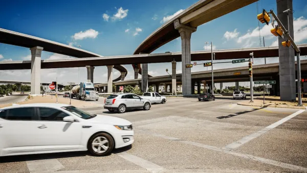
Changes to left turn infrastructure and signal timing led to a 47 to 72 percent drop in fatal and serious injury crashes.

A new Vision Zero report from the city of Austin’s Transportation and Public Works (TPW) department shows that changes to left-turn signal infrastructure at 100 intersections led to a 47 to 72 percent reduction in injuries and fatal crashes involving left turns, which make up over 12 percent of all serious non-freeway crashes in the city. Lina Fisher outlines the report’s findings in in the Austin Monitor.
The TPW report notes that “Of the 73 [intersections] that have collected at least three months of crash data, there has been a 72 percent decrease in injuries and fatalities when compared to the five years prior. That amounts to 37 fewer per year. Notably, all locations also saw decreases in other types of crashes, meaning protected left turns can reduce the overall riskiness of intersections, a ‘positive multiplier effect.’”
This May, a lane reduction on Barton Springs Road led to a 65 percent reduction in speeding, while fatal and serious injury crashes across the city are down by 22 percent.
FULL STORY: Vision Zero’s improvements to protected left turns cut traffic injuries and fatalities in half

Report: Vision Zero Saving Lives in Austin
Safety improvements at major intersections led to a 22 percent reduction in deaths and severe injuries and saved the city over $28 million.

Report: Austin’s State Roads Deadlier Than City Roads
Traffic fatalities and serious injuries grew on state-owned roads in the Texas capital, even as city-owned streets saw death rates plateau.
Austin Outlaws Blocking Bike Lanes
Drivers who park in bike lanes will receive citations of up to $300.

National Parks Layoffs Will Cause Communities to Lose Billions
Thousands of essential park workers were laid off this week, just before the busy spring break season.

Retro-silient?: America’s First “Eco-burb,” The Woodlands Turns 50
A master-planned community north of Houston offers lessons on green infrastructure and resilient design, but falls short of its founder’s lofty affordability and walkability goals.

Delivering for America Plan Will Downgrade Mail Service in at Least 49.5 Percent of Zip Codes
Republican and Democrat lawmakers criticize the plan for its disproportionate negative impact on rural communities.

Test News Post 1
This is a summary

Test News Headline 46
Test for the image on the front page.

Balancing Bombs and Butterflies: How the National Guard Protects a Rare Species
The National Guard at Fort Indiantown Gap uses GIS technology and land management strategies to balance military training with conservation efforts, ensuring the survival of the rare eastern regal fritillary butterfly.
Urban Design for Planners 1: Software Tools
This six-course series explores essential urban design concepts using open source software and equips planners with the tools they need to participate fully in the urban design process.
Planning for Universal Design
Learn the tools for implementing Universal Design in planning regulations.
EMC Planning Group, Inc.
Planetizen
Planetizen
Mpact (formerly Rail~Volution)
Great Falls Development Authority, Inc.
HUDs Office of Policy Development and Research
NYU Wagner Graduate School of Public Service