


The online map builds a comprehensive database of fire prevention and mitigation efforts at every level of government to help agencies coordinate their work and understand the impacts of projects.
A new online dashboard from the state of California tracks wildfire prevention and mitigation work. According to a press release from Governor Gavin Newsom’s office, “For the first time, all fuels management projects are being tracked in one place, on one map, delivering valuable information for project planning and wildfire response.”
The Interagency Treatment Dashboard offers a comprehensive view of wildfire resilience efforts at multiple levels of government, while the Fuel Treatment Effectiveness Dashboard tracks how treatments have impacted fire behavior and firefighting and evacuation efforts. “In 2023, 700,000 acres were treated to help protect against wildfires, with many protected acres receiving multiple treatments such as thinning, prescribed fire, or other practices to improve forest health and community resilience.” This is a major increase from 2021 due in part to a doubling of prescribed treatments.
The dashboards are part of a broader fire resilience strategy that includes increased investments in wildfire resilience, higher staffing levels for firefighting units, an expansion of the state’s aerial firefighting fleet, and technological tools such as drones and AI that can help limit the destruction of fires and save lives.

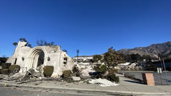
UCLA Experts Offer Critical Support for LA Wildfire Response and Recovery
The UCLA Luskin Center for Innovation offers expert guidance on LA wildfire response and recovery, addressing critical issues like water safety, air quality, equitable rebuilding, and climate adaptation to promote resilience and sustainability.

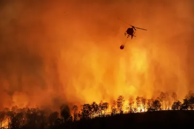
Wildfires Explode Across the West
Multiple massive fires are burning across the Western United States and Canada, prompting governments to explore new mitigation and response strategies.

California Using AI to Get Ahead of Wildfires
The state is pioneering the use of technology to identify wildfire risks and alert firefighters before blazes get out of control.

National Parks Layoffs Will Cause Communities to Lose Billions
Thousands of essential park workers were laid off this week, just before the busy spring break season.

Retro-silient?: America’s First “Eco-burb,” The Woodlands Turns 50
A master-planned community north of Houston offers lessons on green infrastructure and resilient design, but falls short of its founder’s lofty affordability and walkability goals.

Delivering for America Plan Will Downgrade Mail Service in at Least 49.5 Percent of Zip Codes
Republican and Democrat lawmakers criticize the plan for its disproportionate negative impact on rural communities.

Test News Post 1
This is a summary

Test News Headline 46
Test for the image on the front page.

Balancing Bombs and Butterflies: How the National Guard Protects a Rare Species
The National Guard at Fort Indiantown Gap uses GIS technology and land management strategies to balance military training with conservation efforts, ensuring the survival of the rare eastern regal fritillary butterfly.
Urban Design for Planners 1: Software Tools
This six-course series explores essential urban design concepts using open source software and equips planners with the tools they need to participate fully in the urban design process.
Planning for Universal Design
Learn the tools for implementing Universal Design in planning regulations.
EMC Planning Group, Inc.
Planetizen
Planetizen
Mpact (formerly Rail~Volution)
Great Falls Development Authority, Inc.
HUDs Office of Policy Development and Research
NYU Wagner Graduate School of Public Service