


MIT researchers have developed a groundbreaking AI-powered tool that integrates physics-based models to generate realistic satellite images of future flooding, offering communities a powerful way to visualize and prepare for disasters.

Massachusetts Institute of Technology (MIT) scientists have developed an innovative method that combines generative artificial intelligence (AI) with a physics-based flood model to create realistic satellite images of future flooding events. This tool, called the "Earth Intelligence Engine," generates detailed, birds-eye-view visuals of regions expected to flood based on the strength and trajectory of approaching storms. As a proof of concept, the team tested the method on Houston, simulating flooding scenarios similar to Hurricane Harvey in 2017. The AI-generated images that incorporated the physics-based flood model proved more accurate and reliable than those generated by AI alone, which often included errors like flooding in areas of high elevation.
The method uses a conditional generative adversarial network (GAN) to produce realistic images by training two neural networks: one generates synthetic satellite images, and the other evaluates their accuracy against real images. While traditional GAN models risk "hallucinations," or inaccuracies in their results, the integration of physics-based parameters significantly reduces these errors. This enhanced approach provides a trustworthy visualization tool that could help policymakers and residents better understand potential flooding risks, making it more emotionally engaging and actionable than standard color-coded flood maps.
The research highlights the importance of pairing AI with trustworthy data sources, particularly in risk-sensitive scenarios like natural disasters. By visualizing potential flooding before a hurricane hits, this technology has the potential to enhance public preparedness and decision-making, such as evacuation planning. While further training on diverse satellite images is needed to apply the model to other regions, the method demonstrates how AI, combined with physics, can support community-level decision-making and potentially save lives.
FULL STORY: New AI tool generates realistic satellite images of future flooding


Rising Above: Innovative Solutions for Waikīkī’s Sea-Level Challenges
The University of Hawaiʻi at Mānoa’s award-winning Waikīkī sea-level rise adaptation project combines science, architecture, and community input to create scalable solutions for climate resilience and coastal flood mitigation.
FEMA Rule Calls for Updated Flood Modeling
Agency-funded projects will be required to be elevated at least 2 feet above the projected local flood level.

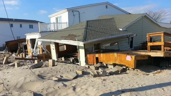
3D Modeling Aids in Predicting Hurricane Damage
Texas researchers are testing the tool in Galveston, where Hurricane Ike caused billions in damage in 2008.

National Parks Layoffs Will Cause Communities to Lose Billions
Thousands of essential park workers were laid off this week, just before the busy spring break season.

Retro-silient?: America’s First “Eco-burb,” The Woodlands Turns 50
A master-planned community north of Houston offers lessons on green infrastructure and resilient design, but falls short of its founder’s lofty affordability and walkability goals.

Delivering for America Plan Will Downgrade Mail Service in at Least 49.5 Percent of Zip Codes
Republican and Democrat lawmakers criticize the plan for its disproportionate negative impact on rural communities.

Test News Post 1
This is a summary

Test News Headline 46
Test for the image on the front page.

Balancing Bombs and Butterflies: How the National Guard Protects a Rare Species
The National Guard at Fort Indiantown Gap uses GIS technology and land management strategies to balance military training with conservation efforts, ensuring the survival of the rare eastern regal fritillary butterfly.
Urban Design for Planners 1: Software Tools
This six-course series explores essential urban design concepts using open source software and equips planners with the tools they need to participate fully in the urban design process.
Planning for Universal Design
Learn the tools for implementing Universal Design in planning regulations.
EMC Planning Group, Inc.
Planetizen
Planetizen
Mpact (formerly Rail~Volution)
Great Falls Development Authority, Inc.
HUDs Office of Policy Development and Research
NYU Wagner Graduate School of Public Service