


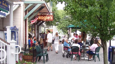
What does it mean to be a 15-minute city?
By Andres Duany and Robert Steuteville:
The 15-minute city is gaining significant traction politically and in planning circles, but what does it mean? Definitions vary, and there is so much slack in the concept—depending on what transportation modes are included—that even conventional suburban sprawl might qualify under some circumstances.
The term offers a two-fold opportunity for urbanists. First, the 15-minute city is a simple enough concept that it resonates with a wide range of people. It was used as a cornerstone of Mayor Anne Hidalgo’s successful reelection in Paris, France, in 2020, and lately former HUD secretary Shaun Donovan has adopted the concept as a key to his New York City mayoral candidacy. Urbanists have an urgent opportunity to help define the 15-minute city, and what it means to sustainable planning and urban design, before it is discredited as a mere political slogan.
Second, the concept can add substantively to the practice of urbanism because it deals with a neglected scale of planning that is larger than the neighborhood, but smaller than the metropolitan region. It shows planners where to locate facilities that serve multiple neighborhoods. It employs conceptual radii drawn on plans in a similar way to urbanists’ familiar quarter-mile "pedestrian shed."
Read more at the source article.
FULL STORY: Defining the 15-minute city

A Better Understanding of Smart Growth Benefits
Smart Growth creates compact, multimodal communities where residents consume less land, drive less, and rely more on non-auto modes. Planners have important stories to tell about the benefits of Smart Growth.

When Planning Issues Become ‘Culture Wars’
‘Commonsense’ urbanism projects are being painted by opponents as sinister plots to limit movement and erode property rights.
A New App Helps Identify 15-Minute City
The new 15-Minute City App generates maps which show the number of services and activities within a 15 minute walk, and and therefore whether an area can be considered a 15-minute neighborhood.

National Parks Layoffs Will Cause Communities to Lose Billions
Thousands of essential park workers were laid off this week, just before the busy spring break season.

Retro-silient?: America’s First “Eco-burb,” The Woodlands Turns 50
A master-planned community north of Houston offers lessons on green infrastructure and resilient design, but falls short of its founder’s lofty affordability and walkability goals.

Delivering for America Plan Will Downgrade Mail Service in at Least 49.5 Percent of Zip Codes
Republican and Democrat lawmakers criticize the plan for its disproportionate negative impact on rural communities.

Test News Post 1
This is a summary

Test News Headline 46
Test for the image on the front page.

Balancing Bombs and Butterflies: How the National Guard Protects a Rare Species
The National Guard at Fort Indiantown Gap uses GIS technology and land management strategies to balance military training with conservation efforts, ensuring the survival of the rare eastern regal fritillary butterfly.
Urban Design for Planners 1: Software Tools
This six-course series explores essential urban design concepts using open source software and equips planners with the tools they need to participate fully in the urban design process.
Planning for Universal Design
Learn the tools for implementing Universal Design in planning regulations.
EMC Planning Group, Inc.
Planetizen
Planetizen
Mpact (formerly Rail~Volution)
Great Falls Development Authority, Inc.
HUDs Office of Policy Development and Research
NYU Wagner Graduate School of Public Service