


A new plan for a carfree bridge between Oregon City and West Linn, across the Willamette River, is quickly taking shape in Oregon.
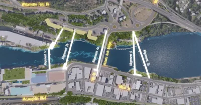
"The Oregon Department of Transportation has just released visualizations of potential alignments for a new carfree bridge across the Willamette River that would connect Oregon City and West Linn," reports Jonathan Maus.
Bike Portland has been reporting on the "Oregon City-West Linn Pedestrian-Bicycle Bridge Concept Plan" since the new bridge was announced last fall. The Oregon Department of Transportation (ODOT) is hoping that having a plan in place will create funding opportunities for new forms of federal funding emerging from the Biden administration's economic recovery efforts. ODOT is planning the new bridge in partnership with the cities of West Linn and Oregon City, Clackamas County, and Metro.
According to Maus, ODOT "understands that a new bridge for bikers, walkers, and mobility device users will help cities on both sides of the river capitalize on future demand given the myriad tourism, real estate, and transportation infrastructure developments planned for the area."
The current plan includes consideration for five potential alignments—three options south of the existing Oregon City-West Linn Arch Bridge and two north of it. The list of five alternatives was culled with the help of public feedback from 15 previous alternatives.
ODOT is already seeking public comment on the bridge plans revealed this week, with an online open house running through April 13.
FULL STORY: Tell ODOT which carfree Oregon City-West Linn bridge to build

Portland's Regional Congestion Pricing Program Widens and Advances
It might be the nation's most significant but least known congestion pricing plan. The plan originally recommended tolling all lanes on segments of two interstates. Four more roads were just added to broaden the plan.
Portland and Multnomah County Push for Lower Speed Limits on Bridges
The Portland Bureau of Transportation and Multnomah County agree on a 30 mph speed limit on five downtown bridges, but the state's department of transportation denied the change on two key spans.
Design Alternatives Revealed for Portland's Burnside Bridge Replacement
Multnomah County is planning to spend $825 million to replace the Burnside Bridge, which engineers say is unlikely to withstand the force of a large eathquake.

National Parks Layoffs Will Cause Communities to Lose Billions
Thousands of essential park workers were laid off this week, just before the busy spring break season.

Retro-silient?: America’s First “Eco-burb,” The Woodlands Turns 50
A master-planned community north of Houston offers lessons on green infrastructure and resilient design, but falls short of its founder’s lofty affordability and walkability goals.

Delivering for America Plan Will Downgrade Mail Service in at Least 49.5 Percent of Zip Codes
Republican and Democrat lawmakers criticize the plan for its disproportionate negative impact on rural communities.

Test News Post 1
This is a summary

Test News Headline 46
Test for the image on the front page.

Balancing Bombs and Butterflies: How the National Guard Protects a Rare Species
The National Guard at Fort Indiantown Gap uses GIS technology and land management strategies to balance military training with conservation efforts, ensuring the survival of the rare eastern regal fritillary butterfly.
Urban Design for Planners 1: Software Tools
This six-course series explores essential urban design concepts using open source software and equips planners with the tools they need to participate fully in the urban design process.
Planning for Universal Design
Learn the tools for implementing Universal Design in planning regulations.
EMC Planning Group, Inc.
Planetizen
Planetizen
Mpact (formerly Rail~Volution)
Great Falls Development Authority, Inc.
HUDs Office of Policy Development and Research
NYU Wagner Graduate School of Public Service